[Revised on 12/17/08]
Carolyn Misch, Senior Land Use Planner in the Northampton planning department, has kindly provided us with more details about the proposed changes to the Zero Lot Line regulations. These details are reproduced below and may also be downloaded as a PDF, but first, here is explanatory text circulated by Ward 3 City Councilor Bob Reckman to the Ward 3 Neighborhood Association Board on December 10:
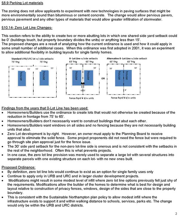
The City’s current zoning allows zero lot line projects in Urban Residential B (URB) and Urban Residential C (URC) districts. Most of the residential area of Ward 3 is comprised of these two residential districts. Eligible properties need only 65’ of frontage rather than 75’ (which is the
standard frontage requirement). This provision was added about 8 years ago to try to encourage greater density. There have been about 10 uses of this provision in the last 8 years.The current zoning allows such projects but requires that:
- A solid fence be built between the structures and that the windows be located to maximize
privacy. These requirements could be waived by the Planning Board.- The rear setback be 30’ rather than the 15’ that is the standard rear setback in these zones.
- The applicant must control both properties. It allows such projects on lots that have 65’ of
frontage rather than the standard 75’ There have been about 10 uses of this provision in the
last 8 years.The proposed change would do several things:
- It would eliminate the fence and window requirements.
- It would change the rear setbacks from 30’ to 15’.
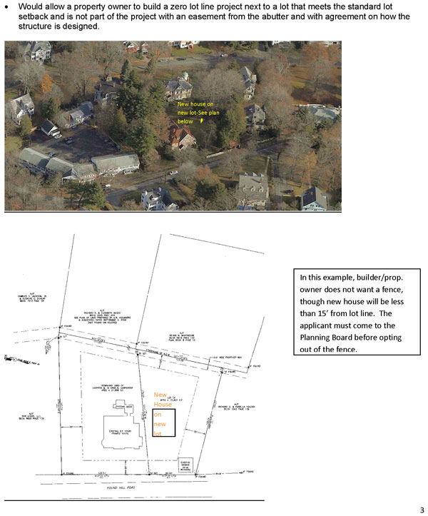
- It would allow a new home or addition by right within the standard 15’ side setback if the
applicant is able to provide an easement from the relevant abutter that has been recorded at
the Registry of Deeds and approved by any mortgage holder. It would eliminate the
requirement that the applicant control both lots. The applicant would need to acquire a legal
easement from the abutter and have it recorded at the registry of deeds. If there is a
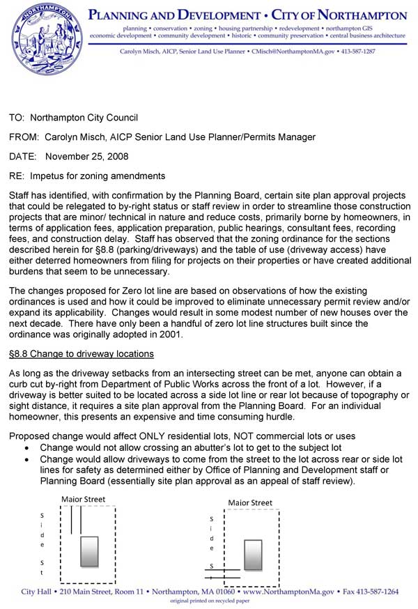
mortgage on the property, the holder of the mortgage would also have to agree.Wayne told me that he had done a rough count based on aerial photos (which are less than
perfect) of the total number of empty lots in the entire City which would be affected. It is about
50. It is important to remember that this change would also affect additions. If we approve it,
people who want to add closer to their lot line would be able to do so if they get and record the
required easement from their abutter.This proposal will be discussed at the joint meeting of the Planning Board and the Ordinance
Committee on Jan. 8 at 8 PM in the Council Chambers. This will be a public hearing, so I
encourage you to come and ask any questions that you have. The meeting starts at 7 PM, but
this change will not be discussed until 8 PM.
The planning department contends these changes are minor and they may well be. However, citizens need more information before they can confirm this judgment. In particular, there appears to be some debate over whether the number of lots affected will be close to 50 or a much larger number.
The maximum possible consequences from the proposed changes need to be spelled out, including the potential percentage increase in impervious surface and potential loss of tree canopy, broken out by ward. As with the new wetlands ordinance, it’s not enough to evaluate the impacts of new rules project by project. Long-term impacts at the ward and city level must also be evaluated.
More generally, the extent of impervious surface, tree canopy, and other critical metrics should be monitored ward by ward and reported to the public on an annual basis.
See also:
Tailoring Infill and the New Urbanism to Northampton
The North Street Neighborhood Association is not opposed to all infill
per se. The “new urbanism” has many appealing features, but three
cautions come to mind.
First, due to Northampton’s chronic
flooding issues, the proportion of impervious surface in a neighborhood
should be closely monitored. A front lawn may not be as “useless” as it
looks, and it can add privacy and quiet to a home. Second, urban heat
island effects should be considered if a neighborhood is at risk of
losing greenspace. Third, any transition from one zoning regime to
another should be gradual, to avoid sudden property tax increases and
to evaluate the effects of the new regime as they unfold, in case
adjustments are needed.
Portland: A Photo Tour of Spiraling Densification
What we see happening is
that planners are never satisfied — let them densify you a little
bit, and they keep coming back for higher and higher densities.
Portland has zoned many formerly single-family neighborhoods for
multifamily.
In neighborhoods that are still zoned for single family, Portland has
reduced the minimum lot size. One result is the “skinny house.” This
is not a row house but a 15-foot-wide single-family detached home on
a 25-foot-wide lot. Portland held a competition to design innovative
skinny houses, but in actual practice they all look almost exactly
alike.
76th before
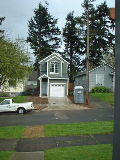
76th after
In 76th before and 76th after you see a skinny house build in the
empty space between two other houses…
Portland, Oregon Voters Sour on Densification Over Time
LA Weekly: “City Hall’s ‘Density Hawks’ Are Changing L.A.’s DNA
“…The deal [says Yaroslavsky] is that there are a number of developers who see an opportunity here to make a killing.”
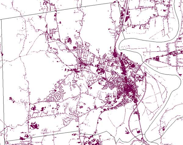
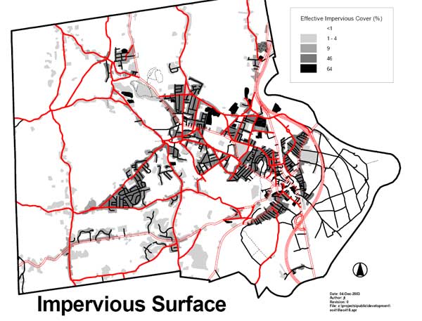
Update from Notre Dame; Critique of Northampton Sector Diagram
These charts show the degree to which impervious surface already overspreads the “receiving areas”. The first chart is from OLIVER, The MassGIS Online Data Viewer. The second chart was prepared by Northampton’s Office of Planning and Development.
Greenspace
is an important amenity for many homebuyers. If in-town living comes to
be seen as less desirable, it is plausible that these buyers will
engage in “leapfrog sprawl”, finding their greenspace in neighboring
towns, and potentially increasing their car use. The bottom line is, if
you want people to live near downtown, you need to ensure it’s an
attractive option for a broad range of people.
City Council Enacts New Wetlands Ordinance, Including 10-Foot Buffers
When illustrating how the new ordinance might be applied, Bruce Young
dwelt on the hypothetical example of a homeowner who wants to build an
accessory apartment on their property, and how relaxed buffer zone
requirements could facilitate that. While this came across as innocuous
and benign, there was no discussion of the cumulative impact of many
landowners encroaching on wetlands. It’s easy to see how the
Conservation Commission, by giving away our flood protection piecemeal
over time, could materially impact the city’s experience during the
next major rainstorm.
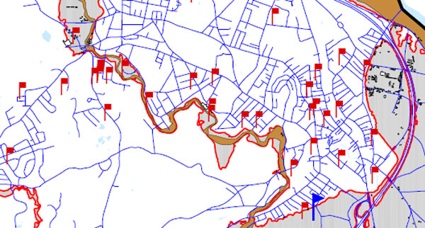
Flooding
is already affecting Northampton’s built-up areas during major storms
[Flood damage reports from Tropical Storm Floyd
pepper downtown Northampton (1999). Note most of the red flags are
outside the traditional 100-year floodplain. This is a sign that
Northampton’s stormwater management systems are stretched even under
the existing wetlands buffer zone regime. We object to ratcheting up
the pressure on our in-town wetlands, a key part of our natural
drainage system.]
As Hurricane Threat Builds, Has Complacency Set In about Flooding?
Infill
sounds great on paper, but when it means paving over green space in
downtown Northampton, it runs contrary to sound flood mitigation
practice. The reality is that much of the remaining green space in
downtown is in low-lying areas that are most susceptible to flooding.
It makes sense to go along with the collective wisdom of the past 350
years and leave them undeveloped.