[Revised August 7, 2007]
Northampton’s Planning Board and City Council Industry Committee endorsed the “Grow Smart Northampton” (PDF) plan in 2003. This plan, a precursor to recent Sustainable Northamption planning, does support infill. Specifically, the plan suggests, “Increase by 10 percent the density of housing in and within walking distance of downtown.” (p.13)
At the same time, Grow Smart Northampton urges a balanced approach to preserve urban green space and the quality of life downtown:
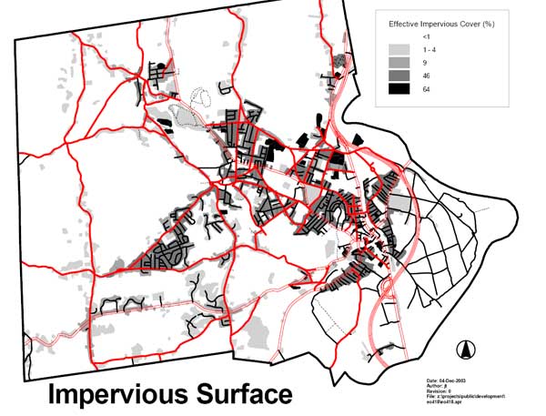
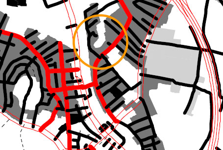
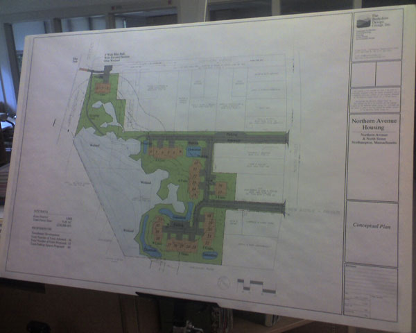
Here are two charts from the Grow Smart Northampton plan, followed by Kohl’s condo proposal. Kohl’s proposed development would add substantial impervious roads, parking lots and buildings to a large, wet, low-lying area off North Street…
Kohl Construction asserts it has the right to place as many as 34 condo units on its 5.49 acre site. This is if Kohl is granted a special permit by Northampton’s Planning Board for a townhouse development. Northampton guidelines call for each townhouse unit to be ‘assigned’ 7,000 square feet of land. The total size of Kohl’s parcel is 238,988 square feet. Kohl’s actual proposal calls for 31 units, which works out to 5.65 units per acre. The current typical density in the North Street area is 2-4 units per acre.
During the permitting process, the city will consider, among other things, issues of roads, access, frontage, setbacks, parking, snow storage and wetlands when evaluating Kohl’s proposal.
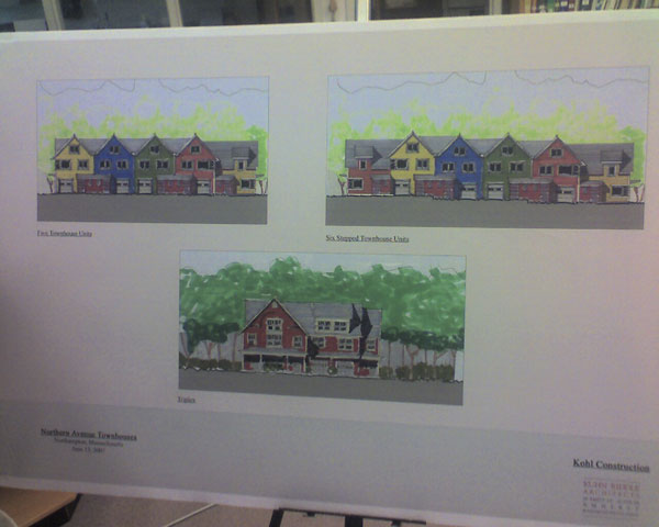
Limiting density per acre serves to protect neighborhood character, mitigate impacts on the environment and utilities, and head off parking and traffic problems. The North Street area is primarily a neighborhood of detached one- and two-family homes. In 1991, a proposed three-unit apartment house on Woodmont Road was blocked by the Zoning Board of Appeals for being out of character with the neighborhood. Much more out of character is Kohl’s proposal for 31 units, consisting of townhouses and a triplex:
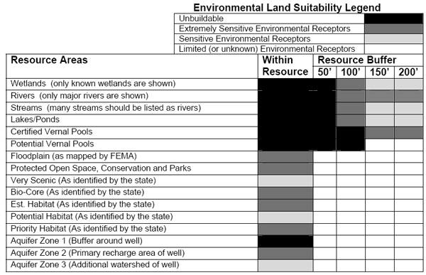
Grow Smart Northampton characterizes the 50-foot buffer zone around wetlands as “Unbuildable”, and the zone 50-100 feet from wetlands as “Extremely Sensitive Environmental Receptors”. The condos proposed by Kohl Construction, however, will encroach within 35 feet of wetlands:
See also:
Kohl’s Condo Proposal: Where Things Stand and What You Can Do
Kohl Construction proposes to build 31 condo units in the forest between North Street and the bike path. This development, with its access roads and 66 parking spaces, will claim 5.49 acres of land…
A wetland centered on Millyard Brook runs through the heart of the forest. The buffer area around a wetland is important in itself, an edge zone of high species diversity that helps regulate water flows into the wetland. These areas are fragile, can take a long time to establish, and are easily disturbed by development. The consequences of development around wetlands are often increased flooding in wet periods and more severe dryness during droughts.
Urban ‘infill’ development is laudable when it reclaims parking lots, brownfields and decayed structures. However, Kohl’s proposal will impact substantial amounts of natural green space, in conflict with the ecological goals of Northampton’s Sustainability Plan…
Alewife Study Group: Impact of Development on Wetlands and Flooding
…As a direct result of development on the Alewife flood plain and its low elevation, there is periodic and significant flood damage in the surrounding communities. A 1981 study by the MDC found property damage in the Alewife area to be the highest of any portion of the Mystic River watershed of which it is a part.
During flood events at Alewife, the Mystic River backs up into the Alewife Brook and Little River areas. Flood waters from Belmont also empty into this area during storm events. During the flood of October, 1996, the Alewife Brook flooded over the Alewife Brook Parkway and into North Cambridge neighborhoods. East Arlington neighborhoods adjacent to Alewife were also inundated with flood water. The Arthur D. Little parking lot was covered by several feet of flood water…
Development pressures will continue to pose an immediate threat to Cambridge’s remaining wetland and flood plain areas. For all of these reasons Cambridge is in desperate need of conservation bylaws….
…Even with the best of compensatory storage schemes it is clear that flooding continues to increase where construction occurs. Therefore, it is the recommendation of FEMA that no construction occur in the 100-year flood plain and this is also the policy of the Cambridge emergency response plan. The state Zoning Act (G.L. Ch. 40A) also encourages municipalities to prohibit or regulate development on flood plains…
The weight of built structures has a significant effect on flood capacity and ought to be a factor in calculating compensatory storage. The weight of a building will compress soil so that it can no longer hold as much water…
And, finally, there has been no consideration given to area-wide flooding conditions. Until now a developer has been allowed to focus exclusively on their own contribution to flooding without an analysis of the general conditions in their area. The Danvers conservation bylaw has corrected this oversight by requiring that “hydrologic analysis shall be based on a reasonable estimate of developed conditions within the entire watershed”.
As Hurricane Threat Builds, Has Complacency Set In about Flooding?
Infill sounds great on paper, but when it means paving over green space in downtown Northampton, it runs contrary to sound flood mitigation practice. The reality is that much of the remaining green space in downtown is in low-lying areas that are most susceptible to flooding. It makes sense to go along with the collective wisdom of the past 350 years and leave them undeveloped.
EPA: Urban Heat Islands
Northampton’s Planning Board and City Council Industry Committee endorsed the “Grow Smart Northampton” (PDF) plan in 2003. This plan, a precursor to recent Sustainable Northamption planning, does support infill. Specifically, the plan suggests, “Increase by 10 percent the density of housing in and within walking distance of downtown.” (p.13)
At the same time, Grow Smart Northampton urges a balanced approach to preserve urban green space and the quality of life downtown:
The quality of life in Northampton remains the envy of many. To maintain it, we will ensure that any future housing growth or industrial development, improves, rather than compromises the quality of life. Growth should be at a human scale and sustainable in the long run. (p.9)
Make sure that Florence business district grows within already existing boundaries. No residential or greenspace should be lost to commercial growth. (p.11)
Parks and greenspace should be used to keep urban and village centers attractive for pedestrian traffic without creating dead spots that impede pedestrian flow. (p.11)
Retain and enhance education, amenities, housing, and character that make city attractive to businesses and customers. (p.11)
Ensure development is sustainable over long-term and is low-polluting. (p.11)
Rewrite city regulatory and non-regulatory objectives to encourage sustainable development friendly to the environment. (p.12)
Preserve vital neighborhoods near downtown, Florence center and throughout the city. (p.12)
Allow housing growth to meet demand without creating stress on municipal services or sense of community. (p.12)
Help build neighborhood cohesion and self-identity. (p.12)
Enhance the beauty of neighborhoods and the livability of them. (p.12)
Reduce traffic congestion downtown, near Coolidge Bridge, on King Street and on Damon Road. (p.13)Make sure downtown is pedestrian friendly… (p.13)
Preserve and expand city holdings of open space, wild lands and small pieces of open land in developed areas. (p.14)
Use open space and recreation to ensure that the urban and village centers are attractive places to live, work and visit. (p.14)
Make more natural areas available for public use. (p.14)
Provide recreation opportunities for individuals of all ages and physical abilities now and for future generations. (p.14)
Add to the city’s conservation land holdings by acquiring small green areas downtown and in villages of Bay State, Leeds and Florence. (p.14)
Provide recreation, conservation and open space opportunities. (p.14)
Discourage development damaging village character of urban/residential neighborhoods. (p.14)
Ensure new downtown development meshes with architectural heritage. (p.14)
Promote traditional neighborhood development patterns. (p.14)
New development should be accompanied by open space preservation so that at least one acre of open space is preserved for each acre of land developed. (p.14)
Encourage development patterns that contribute to, and do not sap, the strength of their neighborhoods. (p.14)
Protect historic buildings defining visual character of downtown. (p.14)
Protect important ecological resources, including surface and groundwater resources, plant communities and wildlife habitat. (p.15)
Preserve ecological and wildlife linkages, especially water-based linkages. (p.15)
Improve quality of storm water discharges. (p.15)
Discourage development in environmentally sensitive areas and encourage environmentally sound development. (p.15)
Protect valuable ecological resources. (p.15)
Provide performance standards to preserve the environment. (p.15)
…unique value of undisturbed resources in pristine areas. (p.17)
Open spaces in convenient locations throughout the neighborhoods. (p.20)
Improve the quality of residential subdivision development and preserve sensitive lands and valuable open space. (p.21)
Preserve especially sensitive lands and valuable open space from development that would damage these resources. (p.21)
It would be critical, however, to ensure that any extra density allowed is consistent with the City’s goals and to ensure that the character of “receiving” zones would be preserved. (p.22)
There are additional infill opportunities that can help maintain vibrant neighborhoods, provide room for growth that doesn’t consume open space and minimize future traffic impacts (p.22)
Using existing regulatory and planning criteria, several of the land-use related City boards (Planning Board, Zoning Board, and Conservation Commission) have permitted development closer to environmental resources in redevelopment areas than in pristine areas. During the Comprehensive Planning process and other City planning efforts, there needs to be more discussion about appropriate buffer zones from environmental resources in different parts of the city and for different environmental resources. (p.58)
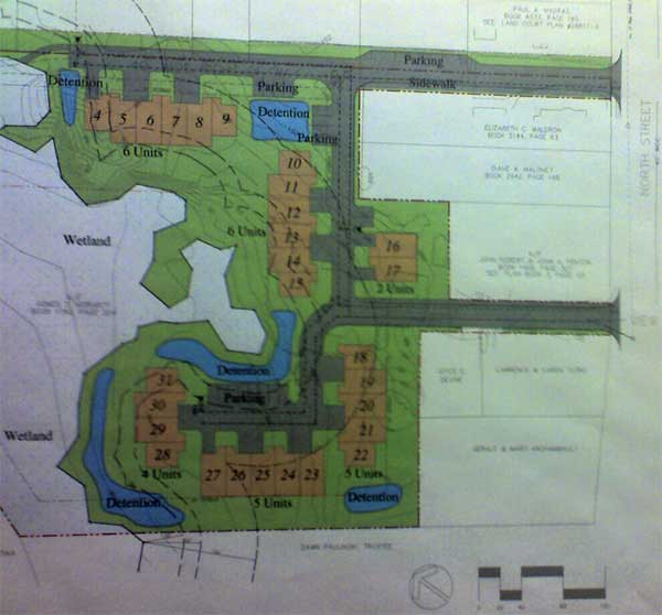
Here are two charts from the Grow Smart Northampton plan, followed by Kohl’s condo proposal. Kohl’s proposed development would add substantial impervious roads, parking lots and buildings to a large, wet, low-lying area off North Street…
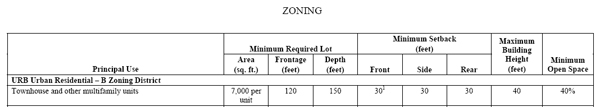
Kohl Construction asserts it has the right to place as many as 34 condo units on its 5.49 acre site. This is if Kohl is granted a special permit by Northampton’s Planning Board for a townhouse development. Northampton guidelines call for each townhouse unit to be ‘assigned’ 7,000 square feet of land. The total size of Kohl’s parcel is 238,988 square feet. Kohl’s actual proposal calls for 31 units, which works out to 5.65 units per acre. The current typical density in the North Street area is 2-4 units per acre.
During the permitting process, the city will consider, among other things, issues of roads, access, frontage, setbacks, parking, snow storage and wetlands when evaluating Kohl’s proposal.
Limiting density per acre serves to protect neighborhood character, mitigate impacts on the environment and utilities, and head off parking and traffic problems. The North Street area is primarily a neighborhood of detached one- and two-family homes. In 1991, a proposed three-unit apartment house on Woodmont Road was blocked by the Zoning Board of Appeals for being out of character with the neighborhood. Much more out of character is Kohl’s proposal for 31 units, consisting of townhouses and a triplex:
Grow Smart Northampton characterizes the 50-foot buffer zone around wetlands as “Unbuildable”, and the zone 50-100 feet from wetlands as “Extremely Sensitive Environmental Receptors”. The condos proposed by Kohl Construction, however, will encroach within 35 feet of wetlands:
See also:
Kohl’s Condo Proposal: Where Things Stand and What You Can Do
Kohl Construction proposes to build 31 condo units in the forest between North Street and the bike path. This development, with its access roads and 66 parking spaces, will claim 5.49 acres of land…
A wetland centered on Millyard Brook runs through the heart of the forest. The buffer area around a wetland is important in itself, an edge zone of high species diversity that helps regulate water flows into the wetland. These areas are fragile, can take a long time to establish, and are easily disturbed by development. The consequences of development around wetlands are often increased flooding in wet periods and more severe dryness during droughts.
Urban ‘infill’ development is laudable when it reclaims parking lots, brownfields and decayed structures. However, Kohl’s proposal will impact substantial amounts of natural green space, in conflict with the ecological goals of Northampton’s Sustainability Plan…
Alewife Study Group: Impact of Development on Wetlands and Flooding
…As a direct result of development on the Alewife flood plain and its low elevation, there is periodic and significant flood damage in the surrounding communities. A 1981 study by the MDC found property damage in the Alewife area to be the highest of any portion of the Mystic River watershed of which it is a part.
During flood events at Alewife, the Mystic River backs up into the Alewife Brook and Little River areas. Flood waters from Belmont also empty into this area during storm events. During the flood of October, 1996, the Alewife Brook flooded over the Alewife Brook Parkway and into North Cambridge neighborhoods. East Arlington neighborhoods adjacent to Alewife were also inundated with flood water. The Arthur D. Little parking lot was covered by several feet of flood water…
Development pressures will continue to pose an immediate threat to Cambridge’s remaining wetland and flood plain areas. For all of these reasons Cambridge is in desperate need of conservation bylaws….
…Even with the best of compensatory storage schemes it is clear that flooding continues to increase where construction occurs. Therefore, it is the recommendation of FEMA that no construction occur in the 100-year flood plain and this is also the policy of the Cambridge emergency response plan. The state Zoning Act (G.L. Ch. 40A) also encourages municipalities to prohibit or regulate development on flood plains…
The weight of built structures has a significant effect on flood capacity and ought to be a factor in calculating compensatory storage. The weight of a building will compress soil so that it can no longer hold as much water…
And, finally, there has been no consideration given to area-wide flooding conditions. Until now a developer has been allowed to focus exclusively on their own contribution to flooding without an analysis of the general conditions in their area. The Danvers conservation bylaw has corrected this oversight by requiring that “hydrologic analysis shall be based on a reasonable estimate of developed conditions within the entire watershed”.
As Hurricane Threat Builds, Has Complacency Set In about Flooding?
Infill sounds great on paper, but when it means paving over green space in downtown Northampton, it runs contrary to sound flood mitigation practice. The reality is that much of the remaining green space in downtown is in low-lying areas that are most susceptible to flooding. It makes sense to go along with the collective wisdom of the past 350 years and leave them undeveloped.
EPA: Urban Heat Islands
Heat islands form as cities replace natural land cover with pavement, buildings, and other infrastructure…