The North Street Neighborhood Association today launches a new series of radio ads on WHMP-AM and a print ad on page A7 of the Daily Hampshire Gazette. We reproduce the text of these ads below, adding links to make it easy to research the issues further and take action.
Script of WHMP Radio Spot (revised 9/12/07, download the mp3 file):
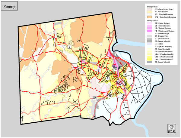
We would like to clarify one point. When we refer to “downtown” areas to be impacted by the proposed Wetlands Ordinance, we are actually referring to most of Northampton’s built-up areas, including residential zoning districts URB and URC:
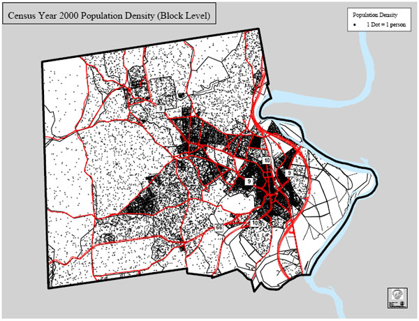
While these areas may represent less than 10% of Northampton’s land area, they are home to a large fraction of the population:

Here is another way to view the distribution of population in Northampton:
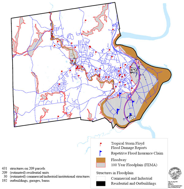
Many of our built-up areas are already prone to flooding during major rainstorms. The red flags below indicate flood damage from Tropical Storm Floyd (1999):
The relationship between flood damage and areas of dense development is made clear when we overlay these two maps together:
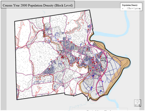
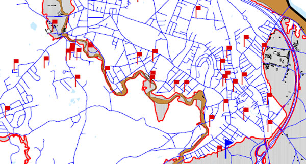
Here is a close-in view of a belt of flood damage downtown and along the Mill River:
In these maps, note how many of the red flags are outside of the classic 100-year floodplain. We quote from the 2004 Flood Mitigation Plan:
See also:
The Wetlands Policy Lawsuit that City Officials Are Afraid Of
We can accept that Northampton should have its key wetlands policies specified by ordinance. However, we disagree that the city needs to lock itself into a buffer zone policy that’s about as weak as any we can find in the state, and at variance with Northampton’s Flood Mitigation Plan of 2004 and its Open Space Plan of 2005. A more balanced ordinance will better serve the long-term interests of the people. Springfield, for example, calls for a 50-foot no-touch buffer zone around wetlands.
NSNA Petition Signature Total Reaches 2,217
This includes 1,470 signatures from residents of Northampton and 747 from non-residents. The population of Northampton is estimated to be 28,592, so over 5% of residents have signed in less than two months. The petitions began circulating on July 21.
As Hurricane Threat Builds, Has Complacency Set In about Flooding?
Infill sounds great on paper, but when it means paving over green space in downtown Northampton, it runs contrary to sound flood mitigation practice. The reality is that much of the remaining green space in downtown is in low-lying areas that are most susceptible to flooding. It makes sense to go along with the collective wisdom of the past 350 years and leave them undeveloped.
Script of WHMP Radio Spot (revised 9/12/07, download the mp3 file):
On September 20, Northampton’s City Council may vote on a wetlands ordinance that will increase the risk of flooding for many of our homes. Wetlands soak up water from storms, but only if we give them the space they need to stay healthy and do their job. Ask your City Councilor to vote No on the proposed wetlands ordinance. Paid for by the North Street Neighborhood Association. Learn more on the web at NorthAssoc.org. That’s N-O-R-T-H-A-S-S-O-C dot O-R-G.Text of ad in today’s Daily Hampshire Gazette:
The Wetlands Ordinance:
Northampton Deserves Better
Call the Mayor’s office today, 413-587-1249
On September 20, an unacceptably weak wetlands ordinance will return to the agenda of Northampton’s City Council. Developers will be encouraged to encroach as close as 10 feet to wetlands in downtown areas. This will facilitate such ill-conceived proposals as Kohl Construction’s 31-unit condo development slated for the woods behind North Street. This area, which likely abuts one or more vernal pools, is known to have experienced flood damage from Tropical Storm Floyd in 1999.
As recently as 2004, the City Council acknowledged the value of wetlands buffer zones when it approved a Flood and Natural Hazard Mitigation Plan. This plan noted that 100-foot buffers around wetlands were an effective strategy to combat flooding, and said that consistently enforcing wetlands regulations in the city was a “priority action”.
In 2005, the City Council approved an Open Space Plan that expressed concerns about how development has been degrading wetlands and cutting into wildlife habitats. It stated, “This loss of habitat and natural flood buffering areas is Northampton’s most serious environmental problem.”
These sound insights appear to have vanished in the face of today’s current planning craze—infill—even as we observe the second anniversary of Hurricane Katrina.
The list of Massachusetts cities that respect the benefits of their wetlands is long, including Stockbridge, Wayland, Hopkinton, Barnstable, Boxborough, Chilmark and Belchertown. Springfield requires a minimum of a 50-foot undisturbed buffer around wetlands. Paradise City, famous for its balance of civilization and nature, deserves no less. Call Mayor Clare Higgins and your City Councilor today and urge them to reject the proposed Wetlands Ordinance.
To learn more about the many benefits of urban forests and wetlands, and how other cities balance development with environmental protection, visit the North Street Neighborhood Association website, www.NorthAssoc.org.
We would like to clarify one point. When we refer to “downtown” areas to be impacted by the proposed Wetlands Ordinance, we are actually referring to most of Northampton’s built-up areas, including residential zoning districts URB and URC:
While these areas may represent less than 10% of Northampton’s land area, they are home to a large fraction of the population:
Here is another way to view the distribution of population in Northampton:
Many of our built-up areas are already prone to flooding during major rainstorms. The red flags below indicate flood damage from Tropical Storm Floyd (1999):
The relationship between flood damage and areas of dense development is made clear when we overlay these two maps together:
Here is a close-in view of a belt of flood damage downtown and along the Mill River:
In these maps, note how many of the red flags are outside of the classic 100-year floodplain. We quote from the 2004 Flood Mitigation Plan:
One great misunderstanding is the belief that floods only happen in the floodplain. With sufficient rain, almost any area will experience at least pockets of surface flooding or overland flooding. Overland flooding in rural areas can result in erosion, washouts, road damage, loss of crops and septic system back-ups. Heavy rain in the more urbanized parts of the City with extensive paved and impervious surfaces can easily overwhelm stormwater facilities resulting in localized flooding and basement damage. Stormwater flooding also contributes to water pollution by carrying silt, oil, fertilizers, pesticides and waste into streams, rivers and lakes. As the intensity of development continues to increase, Northampton will see a corresponding increase in serious stormwater problems. It is therefore important that the City as a whole, not just residents of the identified floodplain, address the need for mitigation.We are concerned that ratcheting up the pressure on the remaining wetlands in our built-up areas will worsen the risk of flooding in future storms.
See also:
The Wetlands Policy Lawsuit that City Officials Are Afraid Of
We can accept that Northampton should have its key wetlands policies specified by ordinance. However, we disagree that the city needs to lock itself into a buffer zone policy that’s about as weak as any we can find in the state, and at variance with Northampton’s Flood Mitigation Plan of 2004 and its Open Space Plan of 2005. A more balanced ordinance will better serve the long-term interests of the people. Springfield, for example, calls for a 50-foot no-touch buffer zone around wetlands.
NSNA Petition Signature Total Reaches 2,217
This includes 1,470 signatures from residents of Northampton and 747 from non-residents. The population of Northampton is estimated to be 28,592, so over 5% of residents have signed in less than two months. The petitions began circulating on July 21.
As Hurricane Threat Builds, Has Complacency Set In about Flooding?
Infill sounds great on paper, but when it means paving over green space in downtown Northampton, it runs contrary to sound flood mitigation practice. The reality is that much of the remaining green space in downtown is in low-lying areas that are most susceptible to flooding. It makes sense to go along with the collective wisdom of the past 350 years and leave them undeveloped.