Today’s Gazette reports New England is experiencing more extreme rainstorms than in the past. We can also expect longer periods of relative dryness.
See also:
Environment Massachusetts: Global Warming Solutions Reports – “When It Rains It Pours” (12/4/07)
In 1999, researchers at the Illinois State Water Survey and the National Climatic Data Center (NCDC) found that storms with extreme precipitation became more frequent by about 3 percent per decade from 1931 to 1996. Our findings are consistent with this result.
In 2004, scientists at NCDC concluded that most of the observed increase in storms with heavy and very heavy precipitation levels since the early 1900s had occurred in the last three decades. In other words, they found that the change in extreme precipitation frequency is unusual and relatively recent.
Moreover, NCDC found that extremely heavy storms are increasing in frequency more rapidly than very heavy storms – which in turn are increasing in frequency more rapidly than heavy storms.
The Seattle Times: “Bigger floodplain, bigger worries” (11/29/07)
In the wake of Hurricane Katrina, the Federal Emergency Management Agency (FEMA) is in the middle of a dramatic revision of the country’s floodplain maps…
FEMA officials say they’re expanding the floodplains because new scanning technology allows them to map topography more accurately, and water flow may have changed over the years from development and erosion…
Having property in a floodplain usually requires that any new development be built several feet higher than existing structures…
This essentially bans new construction, because building above ground level with fill or posts would be prohibitively expensive, local officials said…
In the new flood zones, landowners with a federally regulated home loan would be required to buy flood insurance…
The maps won’t go into effect until late next year or 2009…
“We cannot close our eyes to the events of Katrina,” [said Peter Lewis, Mayor of Auburn, WA], “and the devastation that takes place when infrastructure fails.”
As Hurricane Threat Builds, Has Complacency Set In about Flooding?
[Joe Bastardi, AccuWeater:] New England is fair game from now on until 2025, although the most frequent threats to the Northeast should be later in the run of the cycle… I believe we are in the early to middle stages of the AMO [Atlantic Multidecadal Oscillation]…
Infill sounds great on paper, but when it means paving over green space in downtown Northampton, it runs contrary to sound flood mitigation practice. The reality is that much of the remaining green space in downtown is in low-lying areas that are most susceptible to flooding. It makes sense to go along with the collective wisdom of the past 350 years and leave them undeveloped.
Northampton’s Flood and Natural Hazard Mitigation Plan: Wetlands Buffers of 100 Feet Are an Effective Flood Mitigation Strategy and Should Be Consistently Enforced
One great misunderstanding is the belief that floods only happen in the floodplain. With sufficient rain, almost any area will experience at least pockets of surface flooding or overland flooding… Heavy rain in the more urbanized parts of the City with extensive paved and impervious surfaces can easily overwhelm stormwater facilities resulting in localized flooding and basement damage. Stormwater flooding also contributes to water pollution by carrying silt, oil, fertilizers, pesticides and waste into streams, rivers and lakes. As the intensity of development continues to increase, Northampton will see a corresponding increase in serious stormwater problems. It is therefore important that the City as a whole, not just residents of the identified floodplain, address the need for mitigation…
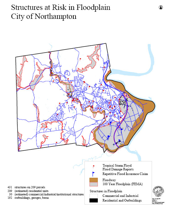
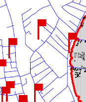
In the chart below, we observe that flood damage from Tropical Storm Floyd [1999] was reported at the end of View Avenue, in the eastern portion of Kohl Construction’s condo site. (p.36)
Northampton Open Space Plan: “This loss of habitat and natural flood buffering areas is Northampton’s most serious environmental problem”
Flooding is already affecting Northampton’s built-up areas during major storms. Weakening wetlands buffer zone requirements downtown will make this worse
EPA: Wetlands and Flood Protection
Wetlands within and downstream of urban areas are particularly valuable, counteracting the greatly increased rate and volume of surface-water runoff from pavement and buildings…
Benefits of Urban Wetlands and Their Buffer Areas
Wetland Values
Wetlands were long thought to be a nuisance because they were not suitable for development or most kinds of agriculture. We now realize that wetlands are not just valuable, they are invaluable. The following is a list of ways in which wetlands benefit people and the environment…
Flood damage control: Wetlands adjacent to rivers (riparian wetlands) can easily survive inundation by floodwaters and often actually benefit from regular flooding. Water that is allowed to flow over wetlands is slowed and partially absorbed, thereby reducing flood damage downstream. Wetlands are said to act as sponges because wetland soils can readily absorb water, and depressions associated with wetlands can fill up. This has the effect of trapping and slowly releasing water that would otherwise rush into the channel and contribute to flooding downstream…
Water supply and groundwater recharge: Wetlands act as sources of water even in very arid regions. A properly functioning wetland can provide water for humans, livestock, and wildlife. Water flows out of wetlands and into the water table below neighboring habitats as these habitats dry out. This process is known as groundwater recharge, and helps habitats around wetlands survive drought. This slow release of stored water also helps rivers maintain flows in the summer…
Extreme downpours and snowstorms are rising in frequency nationally, with the highest increases in New England…Wetlands can moderate both flooding and drought, absorbing excess water during storms and releasing it slowly during periods of dryness. Today’s report underscores the value of our remaining wetlands in Northampton.
Massachusetts saw a 67 percent rise in severe storms during [1948-2006], trailing only Rhode Island and New Hampshire…
…the top 10 severe storms in the state all occurred in the past decade…
…scientists expect that extreme downpours will punctuate longer periods of relative dryness, increasing the risk of drought…
See also:
Environment Massachusetts: Global Warming Solutions Reports – “When It Rains It Pours” (12/4/07)
In 1999, researchers at the Illinois State Water Survey and the National Climatic Data Center (NCDC) found that storms with extreme precipitation became more frequent by about 3 percent per decade from 1931 to 1996. Our findings are consistent with this result.
In 2004, scientists at NCDC concluded that most of the observed increase in storms with heavy and very heavy precipitation levels since the early 1900s had occurred in the last three decades. In other words, they found that the change in extreme precipitation frequency is unusual and relatively recent.
Moreover, NCDC found that extremely heavy storms are increasing in frequency more rapidly than very heavy storms – which in turn are increasing in frequency more rapidly than heavy storms.
The Seattle Times: “Bigger floodplain, bigger worries” (11/29/07)
In the wake of Hurricane Katrina, the Federal Emergency Management Agency (FEMA) is in the middle of a dramatic revision of the country’s floodplain maps…
FEMA officials say they’re expanding the floodplains because new scanning technology allows them to map topography more accurately, and water flow may have changed over the years from development and erosion…
Having property in a floodplain usually requires that any new development be built several feet higher than existing structures…
This essentially bans new construction, because building above ground level with fill or posts would be prohibitively expensive, local officials said…
In the new flood zones, landowners with a federally regulated home loan would be required to buy flood insurance…
The maps won’t go into effect until late next year or 2009…
“We cannot close our eyes to the events of Katrina,” [said Peter Lewis, Mayor of Auburn, WA], “and the devastation that takes place when infrastructure fails.”
As Hurricane Threat Builds, Has Complacency Set In about Flooding?
[Joe Bastardi, AccuWeater:] New England is fair game from now on until 2025, although the most frequent threats to the Northeast should be later in the run of the cycle… I believe we are in the early to middle stages of the AMO [Atlantic Multidecadal Oscillation]…
Infill sounds great on paper, but when it means paving over green space in downtown Northampton, it runs contrary to sound flood mitigation practice. The reality is that much of the remaining green space in downtown is in low-lying areas that are most susceptible to flooding. It makes sense to go along with the collective wisdom of the past 350 years and leave them undeveloped.
Northampton’s Flood and Natural Hazard Mitigation Plan: Wetlands Buffers of 100 Feet Are an Effective Flood Mitigation Strategy and Should Be Consistently Enforced
One great misunderstanding is the belief that floods only happen in the floodplain. With sufficient rain, almost any area will experience at least pockets of surface flooding or overland flooding… Heavy rain in the more urbanized parts of the City with extensive paved and impervious surfaces can easily overwhelm stormwater facilities resulting in localized flooding and basement damage. Stormwater flooding also contributes to water pollution by carrying silt, oil, fertilizers, pesticides and waste into streams, rivers and lakes. As the intensity of development continues to increase, Northampton will see a corresponding increase in serious stormwater problems. It is therefore important that the City as a whole, not just residents of the identified floodplain, address the need for mitigation…
In the chart below, we observe that flood damage from Tropical Storm Floyd [1999] was reported at the end of View Avenue, in the eastern portion of Kohl Construction’s condo site. (p.36)
Northampton Open Space Plan: “This loss of habitat and natural flood buffering areas is Northampton’s most serious environmental problem”
Flooding is already affecting Northampton’s built-up areas during major storms. Weakening wetlands buffer zone requirements downtown will make this worse
EPA: Wetlands and Flood Protection
Wetlands within and downstream of urban areas are particularly valuable, counteracting the greatly increased rate and volume of surface-water runoff from pavement and buildings…
Benefits of Urban Wetlands and Their Buffer Areas
Wetland Values
Wetlands were long thought to be a nuisance because they were not suitable for development or most kinds of agriculture. We now realize that wetlands are not just valuable, they are invaluable. The following is a list of ways in which wetlands benefit people and the environment…
Flood damage control: Wetlands adjacent to rivers (riparian wetlands) can easily survive inundation by floodwaters and often actually benefit from regular flooding. Water that is allowed to flow over wetlands is slowed and partially absorbed, thereby reducing flood damage downstream. Wetlands are said to act as sponges because wetland soils can readily absorb water, and depressions associated with wetlands can fill up. This has the effect of trapping and slowly releasing water that would otherwise rush into the channel and contribute to flooding downstream…
Water supply and groundwater recharge: Wetlands act as sources of water even in very arid regions. A properly functioning wetland can provide water for humans, livestock, and wildlife. Water flows out of wetlands and into the water table below neighboring habitats as these habitats dry out. This process is known as groundwater recharge, and helps habitats around wetlands survive drought. This slow release of stored water also helps rivers maintain flows in the summer…