MSNBC reports yesterday:
William Gray, the hurricane forecast pioneer who founded Colorado State University’s respected storm research team, said CSU would ramp up their prediction for the 2010 season in a report due out on June 2.
“The numbers are going to go up quite high,” Gray said. “This looks like a hell of a year.”
…Weather Services International predicted 18 named storms, 10 hurricanes and five intense hurricanes, rated as Category 3 storm with winds of 110-130 mph, or greater.
That is well above the 1950-2009 averages of 10 named storms, six hurricanes, and three intense hurricanes and slightly above the averages from the more active recent 15-year period of 14 named storm, eight hurricanes and four intense hurricanes…
WSI said the coastal region from the Outer Banks of North Carolina northward to Maine was twice as likely as normal to experience a hurricane this year.
See also:
Comparing the New Hazards Mitigation Plan to the Old One: Wetlands Protection Weakened (11/2/08)
[The new Hazards Mitigation Plan states:] “The last hurricane to make landfall in New England was Hurricane Floyd, a weak category 2 hurricane, in November 1999. Therefore, it is forecasted that, Massachusetts, and the rest of New England, is long overdue for a major hurricane to make landfall. Based on past hurricane and tropical storm landfalls, the frequency of tropical systems to hit the Massachusetts coastline is an average of once out of every six years.” (p.28, emphasis added)
As Hurricane Threat Builds, Has Complacency Set In about Flooding? (8/4/07)
Joe Bastardi, Chief Forecaster of the AccuWeather.com Hurricane Center: “New England is fair game from now on until 2025, although the most frequent threats to the Northeast should be later in the run of the cycle.”
…Infill sounds great on paper, but when it means paving over green space in downtown Northampton, it runs contrary to sound flood mitigation practice. The reality is that much of the remaining green space in downtown is in low-lying areas that are most susceptible to flooding. It makes sense to go along with the collective wisdom of the past 350 years and leave them undeveloped.
Gazette: “Region’s storms going to extremes, report finds” (12/5/07)
Springfield Republican: “Northeast seeing more, fiercer rainstorms in line with global warming predictions, study says” (4/5/10)
Healthy wetlands and wetlands buffers mitigate flooding. Compared to manmade stormwater infrastructure, wetlands are cheap, effective, and low-maintenance forms of flood control. Scientific studies suggest wetlands need 50-foot buffers or more to retard degradation from human activity.
Christian Science Monitor: “How to plan better for New England floods” (4/19/10)
The April 3 Christian Science Monitor uses the occasion of the recent flooding along the New England coast to look at climate trends:
How to plan better for New England floods
As flood waters recede in rain-soaked New England, March’s record-smashing storms highlight the need for planners in the region to place an increased emphasis on reducing flood risks and boosting their communities’ resilience to floods…
Planners need to update the basic information on rainfall intensity they use to determine the adequacy of their projects.
That’s the view of several hydrology specialists, who note that changing rainfall patterns in the area alone have increased the number of floods and appears to have increased their average severity as well over the past 40 years – particularly in the last decade…
The Kohl Construction condominium proposal for North Street relies heavily on stormwater assumptions (see PDF) that may be outdated. Kohl assumes that a typical 24-hour 2-year rainfall is 2.95″, a 10-year rainfall is 4.45″, and a 100-year rainfall is 6.50″. Maybe this is still true, but when you build as close to wetlands as Kohl proposes to, there’s little margin for error.
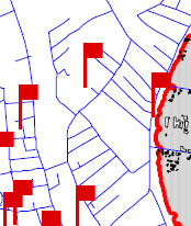
Tropical Storm Floyd Flood Damage Report (1999)
In the map below, the red flag behind View Avenue (the topmost flag) indicates a flood damage report from Tropical Storm Floyd (1999). This area is in the eastern portion of Kohl Construction’s proposed condo site, one of the more elevated portions. We infer that much of Kohl’s property may be at risk from heavy rainfall events.