Today’s Gazette reports on the City Council’s decision to table the new wetlands and vernal pools ordinances until its September 20 meeting:
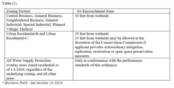
We would like to discuss Mr. Young’s suggestion that the 10-foot buffer zone will only impact a small part of the city. This is true in land area, but not true in population or structures. This table from the proposed new wetlands ordinance shows that nine city zoning districts would become open to some form of 10-foot buffer zone, including Urban Residential-B and Urban Residential-C:
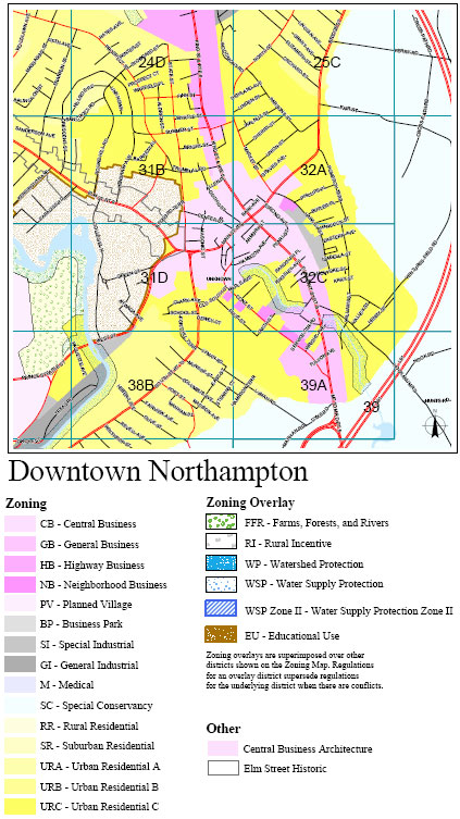
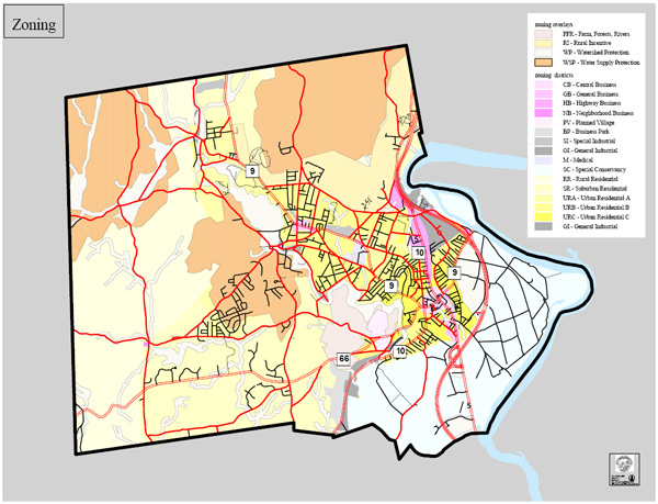
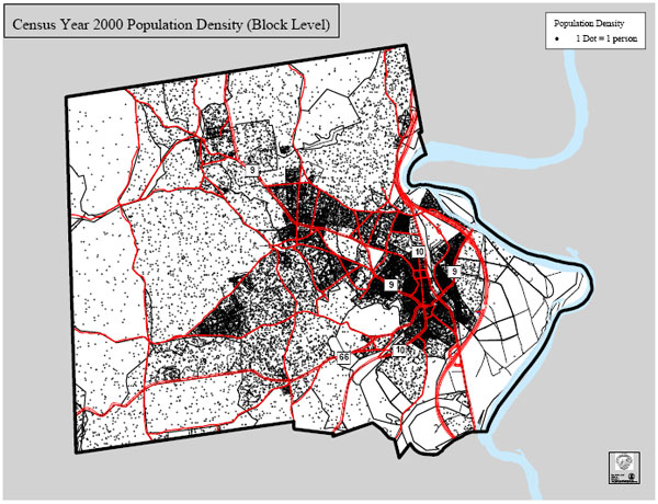
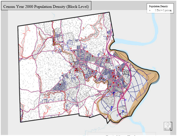
As the following maps and charts show, a sizable fraction of Northampton’s population lives within the nine affected districts. Specifically, 56% of residents live within one mile of the center of downtown or Florence Center. According to the proposed new wetlands ordinance language, increasing this density further is desirable. Downtown residents deserve the flood mitigation benefits of wetlands just as do the people who live in the outlying zones.
We present zoning maps first to show where the affected zones are (see this PDF for more details), followed by population density data from Northampton’s Open Space Plan of 2005.

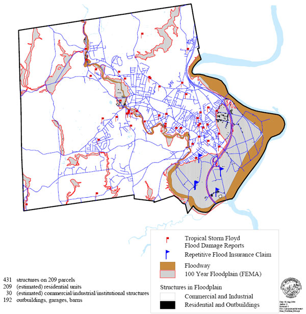
Now let’s review the flood damage reports from Tropical Storm Floyd (1999), taken from Northampton’s Flood Mitigation Plan. We see a cluster of reports in the dense downtown area, underscoring how important it is not to further compromise our natural flood mitigation systems there.
Now let’s overlay the flood damage map onto the population density map. We see the flood damage reports tend to cluster in the denser areas:
Here we zoom in on the downtown flood damage reports:
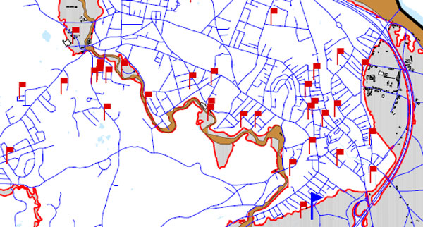
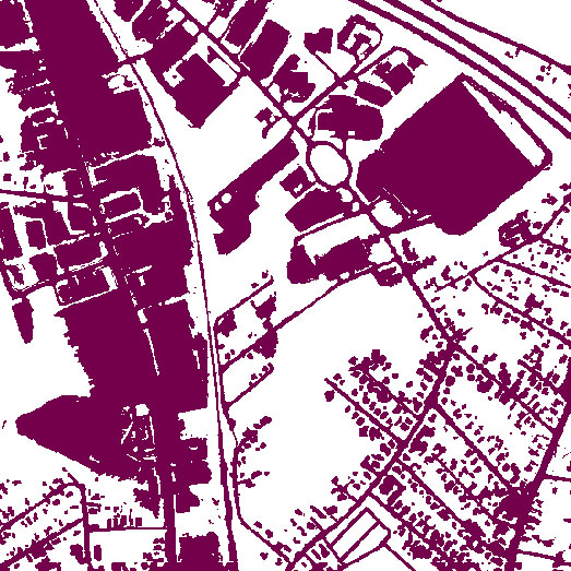
Notice the line of flood damage reports just to the west of King Street. From the chart below (source: OLIVER), we observe that King Street has an exceptional amount of impervious surfaces. The flooding suggests that downtown Northampton’s stormwater management systems–natural and man-made–are already stressed.
See also:
The Republican: Vernal pools remain an issue
Thomas McCurry, who lives at 193 North St., told the council that allowing a smaller buffer would be a mistake.
“People have moved here from elsewhere to escape congestion in overly developed areas,” he said.
Former city councilor Alex D. Ghiselin said that 10 feet is “just not enough protection.”
“This is an issue between the present and the future,” Ghiselin said. “Growth that erodes the natural system isn’t smart.”
Flooding Incidents in the North Street Neighborhood: 2003-2007
Letters from Residents Describe Groundwater and Sewage Issues Around North Street
EPA: Wetlands and Flood Protection
Wetlands within and downstream of urban areas are particularly valuable, counteracting the greatly increased rate and volume of surface-water runoff from pavement and buildings…
A one-acre wetland can typically store about three-acre feet of water, or one million gallons. An acre-foot is one acre of land, about three-quarters the size of a football field, covered one foot deep in water. Three acre-feet describes the same area of land covered by three feet of water. Trees and other wetland vegetation help slow the speed of flood waters. This action, combined with water storage, can actually lower flood heights and reduce the water’s destructive potential. (Source: EPA)
As Hurricane Threat Builds, Has Complacency Set In about Flooding?
Infill sounds great on paper, but when it means paving over green space in downtown Northampton, it runs contrary to sound flood mitigation practice. The reality is that much of the remaining green space in downtown is in low-lying areas that are most susceptible to flooding. It makes sense to go along with the collective wisdom of the past 350 years and leave them undeveloped.
After nearly two years of talks, proposed laws designed to protect wetlands and vernal pools are still a work in progress.
…the council tabled the entire ordinance after several councilors said they would not support splitting the ordinance into two.
Rather, they said they want to see whether the Conservation Commission can work out revisions acceptable to city groups such as the Greater Northampton Chamber of Commerce, on the part of the ordinance that strengthens protection of vernal pools.
…said Ward 3 City Councilor Marilyn A. Richards. “Everybody is in agreement that we need strong vernal pool protections.”
…while vernal pools have often been the most contentious subject of debate, it was the entire wetlands ordinance as proposed that irked several residents speaking during Thursday’s public comment session…
“I feel this is now bad legislation that doesn’t advance the protection of wetlands and vernal pools,” said Joanne Montgomery, of 161 Crescent St…
“This is not the bill the Conservation Commission wanted to bring the City Council,” said Alex D. Ghiselin, of 164 Riverside Drive, who took aim at the 10-foot encroachment zone outlined in the proposal.
Ghiselin described the city’s stormwater infrastructure as “undersized and unrepaired.” Wetlands are a natural stormwater drainage system “that works and really is one that we more and more come to depend on,” he said…
Bruce W. Young said the zoning districts subject to the 10-foot no-encroachment zone represent less than 5 percent of the city’s entire area.
We would like to discuss Mr. Young’s suggestion that the 10-foot buffer zone will only impact a small part of the city. This is true in land area, but not true in population or structures. This table from the proposed new wetlands ordinance shows that nine city zoning districts would become open to some form of 10-foot buffer zone, including Urban Residential-B and Urban Residential-C:
As the following maps and charts show, a sizable fraction of Northampton’s population lives within the nine affected districts. Specifically, 56% of residents live within one mile of the center of downtown or Florence Center. According to the proposed new wetlands ordinance language, increasing this density further is desirable. Downtown residents deserve the flood mitigation benefits of wetlands just as do the people who live in the outlying zones.
We present zoning maps first to show where the affected zones are (see this PDF for more details), followed by population density data from Northampton’s Open Space Plan of 2005.
Now let’s review the flood damage reports from Tropical Storm Floyd (1999), taken from Northampton’s Flood Mitigation Plan. We see a cluster of reports in the dense downtown area, underscoring how important it is not to further compromise our natural flood mitigation systems there.
Now let’s overlay the flood damage map onto the population density map. We see the flood damage reports tend to cluster in the denser areas:
Here we zoom in on the downtown flood damage reports:
Notice the line of flood damage reports just to the west of King Street. From the chart below (source: OLIVER), we observe that King Street has an exceptional amount of impervious surfaces. The flooding suggests that downtown Northampton’s stormwater management systems–natural and man-made–are already stressed.
See also:
The Republican: Vernal pools remain an issue
Thomas McCurry, who lives at 193 North St., told the council that allowing a smaller buffer would be a mistake.
“People have moved here from elsewhere to escape congestion in overly developed areas,” he said.
Former city councilor Alex D. Ghiselin said that 10 feet is “just not enough protection.”
“This is an issue between the present and the future,” Ghiselin said. “Growth that erodes the natural system isn’t smart.”
Flooding Incidents in the North Street Neighborhood: 2003-2007
Letters from Residents Describe Groundwater and Sewage Issues Around North Street
EPA: Wetlands and Flood Protection
Wetlands within and downstream of urban areas are particularly valuable, counteracting the greatly increased rate and volume of surface-water runoff from pavement and buildings…
A one-acre wetland can typically store about three-acre feet of water, or one million gallons. An acre-foot is one acre of land, about three-quarters the size of a football field, covered one foot deep in water. Three acre-feet describes the same area of land covered by three feet of water. Trees and other wetland vegetation help slow the speed of flood waters. This action, combined with water storage, can actually lower flood heights and reduce the water’s destructive potential. (Source: EPA)
As Hurricane Threat Builds, Has Complacency Set In about Flooding?
Infill sounds great on paper, but when it means paving over green space in downtown Northampton, it runs contrary to sound flood mitigation practice. The reality is that much of the remaining green space in downtown is in low-lying areas that are most susceptible to flooding. It makes sense to go along with the collective wisdom of the past 350 years and leave them undeveloped.