Beavers bore the brunt of the blame for rising waters in Barrett Street marsh in 2006, but some believe encroaching development played a role. Let’s revisit a Gazette article from March 17, 2006:
See also:
EPA: Wetlands and Flood Protection
Wetlands within and downstream of urban areas are particularly valuable, counteracting the greatly increased rate and volume of surface-water runoff from pavement and buildings…
A one-acre wetland can typically store about three-acre feet of water, or one million gallons. An acre-foot is one acre of land, about three-quarters the size of a football field, covered one foot deep in water. Three acre-feet describes the same area of land covered by three feet of water. Trees and other wetland vegetation help slow the speed of flood waters. This action, combined with water storage, can actually lower flood heights and reduce the water’s destructive potential. (Source: EPA)
Northampton’s Flood and Natural Hazard Mitigation Plan: Floyd Flood Damage Reported Behind View Avenue; Avoid Building on Filled Wetlands
In a table of Existing Mitigation Strategies, the plan includes a “100 foot buffer around wetlands and the wetland resource area itself…” It says this strategy has been “Effective”, and says that an option to improve it would be to “Strengthen Wetland Ordinance”…
One of the “Priority Actions” is to “Consistently enforce the Wetlands Protection Act to maintain the integrity of the 200’ riverfront area, wetlands and wetland buffer areas.”
Downtown Flooding in the Wake of Tropical Storm Floyd (1999)
The red flags indicate flood damage reports. There is a cluster just west of King Street:
Beaver trapping extended, Some still oppose bid to lower marsh in Northampton
The Health Department on Thursday granted a 10-day extension on the emergency permit it issued last week, after declaring rising waters in the marsh a threat to human health and safety…
Public works officials say the beavers have caused the water level in the marsh, located just north of downtown, to climb nearly four feet above acceptable levels.
They also say the animals have created conditions that could cause hazardous flooding on streets around the marsh during spring rains and flood season…
Public works officials estimate some 10 to 20 beavers could be in the marsh, and say their dams have compromised the water-drainage system in the area.
Detention ponds and a sedimentation basin are not functioning properly, nor are oil and water separators in the ground around Super Stop & Shop on King Street, according to city officials…
Owned and maintained by the city, the approximately 22-acre Barrett Street marsh is located west of King Street and south of Barrett Street…
…The city has been sued over problems in the marsh and has a responsibility to maintain the area’s water infrastructure as part of a mediated agreement involving neighborhood residents…
Ward 1 City Councilor Maureen T. Carney, said residents around the marsh are anxious about the potential for flooding, particularly on Church Street, which was subject to heavy flooding and property damage years ago…
Several city residents are protesting the city’s actions and calling for public hearings. Some say the city has created the problem by the way it has allowed the area to develop.
“I suspect water problems will persist long after the beavers move on,” said Joanne Montgomery, a former Conservation Commission member, as she addressed the council Thursday.
See also:
EPA: Wetlands and Flood Protection
Wetlands within and downstream of urban areas are particularly valuable, counteracting the greatly increased rate and volume of surface-water runoff from pavement and buildings…
A one-acre wetland can typically store about three-acre feet of water, or one million gallons. An acre-foot is one acre of land, about three-quarters the size of a football field, covered one foot deep in water. Three acre-feet describes the same area of land covered by three feet of water. Trees and other wetland vegetation help slow the speed of flood waters. This action, combined with water storage, can actually lower flood heights and reduce the water’s destructive potential. (Source: EPA)
Northampton’s Flood and Natural Hazard Mitigation Plan: Floyd Flood Damage Reported Behind View Avenue; Avoid Building on Filled Wetlands
In a table of Existing Mitigation Strategies, the plan includes a “100 foot buffer around wetlands and the wetland resource area itself…” It says this strategy has been “Effective”, and says that an option to improve it would be to “Strengthen Wetland Ordinance”…
One of the “Priority Actions” is to “Consistently enforce the Wetlands Protection Act to maintain the integrity of the 200’ riverfront area, wetlands and wetland buffer areas.”
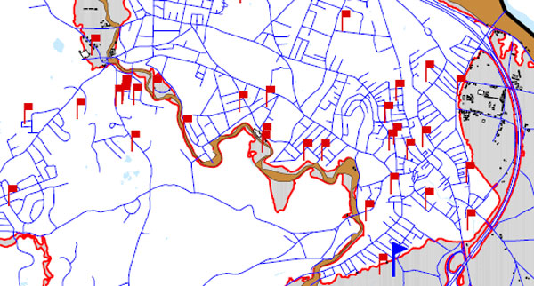
Downtown Flooding in the Wake of Tropical Storm Floyd (1999)
The red flags indicate flood damage reports. There is a cluster just west of King Street: