[11/13/08 update – Notre Dame Professor Philip Bess sent us this comment and authorized us to share it with you:
We share your commitment to green space in Northampton, both usable and preserved; and are cognizant of the low-lying downtown areas prone to flooding. I just want to reassure you here that even if our concern for these issues is not immediately apparent to you now, we view nature preserves and properly planned parks and squares and streets as integral to good urban design; and this will be apparent in our final presentation. Please note too that the colored zones of our sector diagram refer to long-term suggestions for both the preservation of natural and agricultural land and the location of future development. We have no specific recommendations as to how these goals should be implemented, a subject and process which are concerns for the people of Northampton to address and resolve among yourselves.]
The Northampton Design Forum announced the following update today:
Greetings from South Bend,
The Notre Dame urban design studio has been hard at work since our charrette in September. We’ve been refining our ideas, creating new plans, and illustrating them with more perspective views. We presented all of this at our mid-term review, which was attended by several guests from Northampton, but we want to make sure everyone has a chance to see our progress and give us feedback, so we’ve uploaded all of our recent work on to our website.
http://sites.google.com/site/northamptoncharrette/
Please take a look and let us know what you think. We still have a lot of work to do before the end of the semester, so now is the chance for you to influence the direction we take in the next month. No suggestions are too small or too large, so send us an email with your thoughts.(no******************@***il.com). We look forward to hearing from you.
– The Notre Dame Studio
This Sector Diagram (Intervention Strategy) on the charrette website is particularly interesting, even as it gives cause for concern:
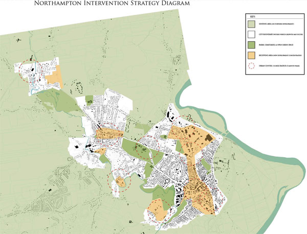
The light green areas are tagged “no further development”. Two concerns immediately arise. First, property owners in the light green areas might object to being shut down so completely. Second, without careful protection for greenspace in the orange and white areas, developers might perceive an open invitation to concrete these spaces over. Not only will this make in-town areas less pleasant and attractive, it will increase flooding risk, as the orange and white areas include some of the most low-lying parts of the city.
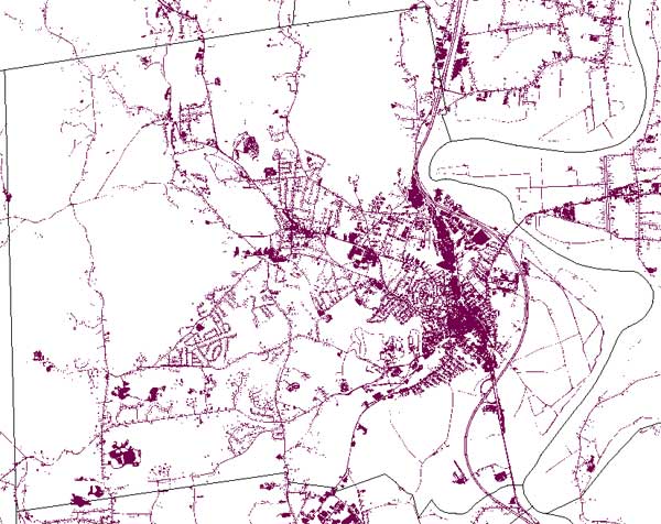
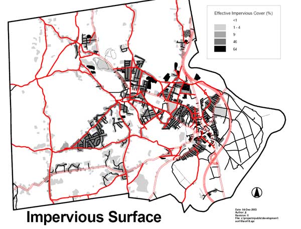
These charts show the degree to which impervious surface already overspreads the “receiving areas”. The first chart is from OLIVER, The MassGIS Online Data Viewer. The second chart was prepared by Northampton’s Office of Planning and Development.
Greenspace is an important amenity for many homebuyers. If in-town living comes to be seen as less desirable, it is plausible that these buyers will engage in “leapfrog sprawl”, finding their greenspace in neighboring towns, and potentially increasing their car use. The bottom line is, if you want people to live near downtown, you need to ensure it’s an attractive option for a broad range of people.
See also:
Video and Slides: Final Presentation of Design Northampton Week
Complete Slides from Northampton Design Week Opening Presentation
Flooding
is already affecting Northampton’s built-up areas during major storms
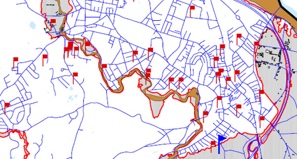
[Flood damage reports from Tropical Storm Floyd
pepper downtown Northampton (1999). Note most of the red flags are
outside the traditional 100-year floodplain. This is a sign that
Northampton’s stormwater management systems are stretched even under
the existing wetlands buffer zone regime. We object to ratcheting up
the pressure on our in-town wetlands, a key part of our natural
drainage system.]
New Hazards Mitigation Plan Reflects Weakened Protection for Wetlands
“…it is forecasted that, Massachusetts, and the rest of New
England, is long overdue for a major hurricane to make landfall. Based
on past hurricane and tropical storm landfalls, the frequency of
tropical systems to hit the Massachusetts coastline is an average of
once out of every six years.” (p.28)
Northampton’s
Flood and Natural Hazard Mitigation Plan: Floyd Flood Damage Reported
Behind View Avenue; Avoid Building on Filled Wetlands (emphasis added)
…Northampton can experience flooding in any part of the City. One great misunderstanding is the belief that floods only happen in the floodplain.
With sufficient rain, almost any area will experience at least pockets
of surface flooding or overland flooding. Overland flooding in rural
areas can result in erosion, washouts, road damage, loss of crops and
septic system back-ups. Heavy rain in the more urbanized parts of the
City with extensive paved and impervious surfaces can easily overwhelm
stormwater facilities resulting in localized flooding and basement
damage. Stormwater flooding also contributes to water pollution by
carrying silt, oil, fertilizers, pesticides and waste into streams,
rivers and lakes. As the intensity of development continues to
increase, Northampton will see a corresponding increase in serious
stormwater problems. It is therefore important that the City as a
whole, not just residents of the identified floodplain, address the
need for mitigation. Flood and hazard mitigation is any preventive
actions a community can take to reduce risks to people and property and
minimize damage to structures, infrastructure and other resources from
flood or other hazardous events. Hazard mitigation and loss prevention
is not the same thing as emergency response. Some flood loss reduction
can be achieved by components of response plans and preparedness plans,
such as a flood warning system or a plan to evacuate flood prone areas.
However, warning and evacuation deal only with the immediate needs
during and following a flood event. Hazard mitigation is much more
effective when it is directed toward reducing the need to respond to
emergencies, by lessening the impact of the hazard ahead of time. (Massachusetts Department of Environmental Management 1997, 3)…
The Economic Value of Wetlands: Wetlands’ Role in Flood Protection in Western Washington
…Episodic
flooding along rivers and streams in the lowlands of Western Washington
has become a recurrent theme of recent years. Development practices
that eliminate or compromise natural systems capable of controlling
runoff appear to be exacerbating flooding problems in many areas. This
highlights the importance of the remaining natural systems capable of
attenuating flood flows, particularly wetlands, in the region’s
defenses against increasingly destructive floods…
EPA: Urban Heat Islands
The
term “heat island” refers to urban air and surface temperatures that
are higher than nearby rural areas. Many U.S. cities and suburbs have
air temperatures up to 10°F (5.6°C) warmer than the surrounding natural
land cover.
The heat island sketch pictured here shows a city’s heat island
profile. It demonstrates how urban temperatures are typically lower at
the urban-rural border than in dense downtown areas. The graphic also
show how parks, open land, and bodies of water can create cooler
areas….
Suburban ‘Raise the Drawbridge’ Sentiment Motivates Some Smart Growth Policies
Steven Greenhut,
a columnist for the Orange County Register, says that Smart Growth
policies that ignore people’s living preferences will fail and make
things worse (11/23/04):
Bozeman is an interesting case study because it is small and because the Smart Growthers have strong control of the city…
…the
real problem is that city and county officials are trying to stop
suburban growth around the city by imposing Portland-style growth
controls. Officials insist that new developments are far more densely
packed than the market demands…On a practical level, these
Smart Growth policies are counterproductive. Restricting growth in the
city, or creating unattractive high-density projects in a place awash
in open space, only pushes people farther out into the countryside. In
Belgrade, eight miles away, one finds market-driven suburban-style
subdivisions. That city does not have many restrictions, and those who
cannot afford Bozeman or who want a bigger place simply move away, thus
promoting the sprawl that Smart Growthers are trying to stop…
Photo Essay: 10 Reasons People Like Trees Around Them; Will the Sustainable Northampton Plan
Put Urban Trees at Risk?
“Planning for Trees” by Henry Arnold, Planning Commissioners Journal, January/February 1992
A
recent survey by the American Forestry Association of twenty American
cities found that, on average, only one tree is planted for every four
removed…
Our urban centers need to become more attractive to
help counter the continuation of a sprawl pattern of development. If
the appeal of low density, widely scattered development is derived from
the need to be closer to nature, then making trees an integral part of
the urban habitat will help make our town and city centers more
desirable places to live and work. It is profoundly important to see
this linkage between making cities and towns more “liveable” and
stemming the continued spread of scattered development across the
countryside…
“Growing Greener: Conservation Subdivision Design” by Randall Arendt, Planning Commissioners Journal, Winter 1999
A
national survey of homebuyers conducted in 1994 by American Lives
revealed that of 39 features critical to their choice, homebuyers
ranked “lots of natural open space” and plenty of “walking and biking
paths” as the third and fourth highest rated factors affecting their
decisions…
Although the groundwater impact of an individual
development may not be terribly significant, the cumulative effect of
hundreds of acres of native woodland and meadows being evenly graded
and covered with streets, driveways, patios, rooftops, and lawns (which
allow for a surprisingly high amount of runoff) can be very
considerable.
Berkeley, California: Cautions on Infill
In
1990, 60 percent of New Yorkers said they would live somewhere else if
they could, and in 2000, 70 percent of urbanites in Britain felt the
same way. Many suburbanites commute hours every day just to have “a
home, a bit of private space, and fresh air.”
New York Times: “Vibrant Cities Find One Thing Missing: Children”
After
interviewing 300 parents who had left the city, researchers at Portland
State found that high housing costs and a desire for space were the top
reasons…
Portland, Oregon Voters Sour on Densification Over Time
Smart Growth with Balance: The American Planning Association
All
development — including redevelopment, infill development, and new
construction in urbanizing areas — should plan for biodiversity and
incorporate green infrastructure. Green infrastructure helps to
maintain natural ecosystems, including clean air and water; reduces
wildlife habitat fragmentation, pollution, and other threats to
biodiversity. It also improves the quality of life for people.
UMass Press: “Natural Land: Preserving and Funding Open Space”
Protecting
open space is often about protecting what makes a community special and
unique… At the small-town or village scale, a forested hillside or
surrounding farmland helps create a unique sense of place. Furthermore,
preserving open space helps to create distinct edges that stop the
blurring of community boundaries that is characteristic of urban
sprawl. Defining what is unique about one’s community and identifying
places that are special to local residents is an important part of the
overall planning process (Hester 1990)…
The Ecological Cities Project: Greenspace in “The Humane Metropolis”
A
metropolis (i.e., metro region or citistate) is considered green if it
fosters humans’ connections to the natural world — an idea Anne
Whiston Spirn promoted in her seminal 1984 book The Granite Garden.
Spirn rejected the idea — easily absorbed if one watches too many
“concrete jungle” films, or even televised nature documentaries —
that the natural world begins beyond the urban fringe. “Nature in the
city,” she wrote, “must be cultivated, like a garden, rather than
ignored or subdued.”
Rutherford Platt, “Regreening the Metropolis: Pathways to More Ecological Cities”
In the 1950s, the conventional wisdom–for the affluent at least–was
that cities are where people are, and the country is where you go on
weekends and vacations to find Nature in some place bucolic or
maritime. But today, even for those who can afford it, the time and
cost of escaping the metropolis has grown with the spread of the
metropolis itself and the growing numbers of vehicles trying to leave
it… Meanwhile, those who cannot afford to sit in traffic in their
SUV–the poor, the elderly, the infirm–are sentenced to live out their
lives in the metropolitan environment, come what may…
…cities and metropolitan areas, now too large to conveniently escape, must themselves be viewed as incorporating both built and unbuilt
environments… And into the bargain, the urban environment will prove
to be more habitable, more sustainable, more “ecological”…