The intent of Northampton’s new Wetlands Ordinance has been a hot topic of conversation at the recent Conservation Commission hearings for Kohl Construction’s condo proposal for North Street. What kinds of disturbance are acceptable within 10, 35 and 50 feet of a wetland in our zoning district (URB)? What kinds of mitigation balance a given amount of disturbance in a wetland buffer zone? Is it reasonable to rely on promises to respect wetlands buffers when past promises have been frequently violated by others?
Kohl’s current proposal requests a waiver from the Conservation Commission in order to encroach to within 35 feet of wetlands.
The next Kohl hearing takes place on May 14, 5:30pm at the City Hall Hearing Room, 210 Main Street, 2nd floor (enter via the back door).
Ahead of this hearing, let’s give a close examination to how the new Wetlands Ordinance was presented to City Council at its 9/20/07 meeting. This was the first of two readings. The ordinance was approved at its second reading in a 7-2 vote of the council on 10/4/07.
Here is a Vimeo video of the 9/20/07 City Council meeting. This video is courtesy of Northampton Community Television. It is 3 hours and 15 minutes long, and captures virtually the entire meeting except for a brief portion of the public comment period at the beginning. A DVD of the recording can be borrowed from Forbes Library.
Here is a partial transcript of the meeting as prepared by Stephen Hathaway:
Video time 41:34
Alex Ghiselin (former City Councilor, speaking in the public comment period):
I apologize to the council for coming two sessions in a row and saying the same thing. The Mayor says democracy is messy, I say it is repetitive, and I’m here to prove it. My first rule of politics is compromise. The wetlands ordinance before you tonight has the look of that healthy process. It took a long time, involved a lot of people, has the support of a lot of environmentalists. So what’s the problem?Despite the ruckus that has been raised in the last couple of months, it has really been entirely an arm-wrestling match between the mayor and members of the Conservation Commission, and the mayor had all the muscle. Over the four years that it took, she has had the opportunity to appoint, re-appoint, or not appoint, every member of the Conservation Commission…
At least one member, a talented guy, a chair, past chair, resigned because of this process. When the Conservation Commission needs legal advice, it has to go, hat in hand, like every commission and board, including the city council, to the mayor. And if she agrees, a legal opinion comes back, through the mayor’s office, and through the mayor’s agenda.
It’s not a dark plot. It’s how I’d run it if I were smart, and the mayor. But it’s not open, and we really need, I think, a more robust process. The
planning staff works for the mayor, and they’re not likely to cross her in public or in private. So what sounds like a lot of different voices, are
really people working within the parameters set by the mayor. From the beginning there was a bottom line, and the conversation finally got there.
When it became clear that the mayor was willing to throw a bunch of the babies out of the window, the environmental community grabbed the one it cared most about, vernal pools.But that’s a choice we shouldn’t have had to make. And my feeling is that the real question is, why, after the last 40 years, the
building in what is really the floodplain of the small rivers and brooks, why we don’t stop, and measure what 15 inches of rain in 24 hours would look like in residential neighborhoods like mine. I’m really worried.This past spring, the Mill River crested at the highest point on record. Not because of record rainfall, but because the city is shedding water faster than ever. Meadowbrook was just that in 1970, 10 acres of flat pasture with wetlands. It could buffer a storm surge from a large section of Florence; High St.; the uplands, draining down from above.
Today, that storm water is much more likely to end up in the basement of a house on Federal St. There are some 40 detention ponds around the city, most of them poorly engineered and maintained. It worries me. We will get a 100-year storm, and the lessons that we learned about the Connecticut River have not been applied to the rest of the system. I just can’t believe that building in the natural drainage system of the city. It seems to me that smart growth, in fact, bears the same relation to smart growth that Blue Skies, President Bush’s clean air policy, has to do with clean air…
Video time 69:05
Paul Wetzel, then chair of the Conservation Commission:
OK, what do you want to know?Mayor Clare Higgins:
It went back to you convening a working group. Could you tell the council what your recommendations are for amendments?Paul Wetzel:
We did have a working group, and…we had the report from Mickey Marcus prepared for the Chamber of Commerce, and we also had a report from Bryan Windmiller who works for HYLA, that’s a consultant group in Concord that was instigated by a private citizen. Interestingly enough, those two reports were very similar. And, um, we went back and forth, we basically did a couple of things. One, we set up a series of definitions. I’m assuming you have these in front of you… so we set up a series of definitions, that hadn’t been there previously. And then we changed (actually recommended by Windmiller) the minimum size of a vernal pool from a volume to an aerial measurement. And we
did that, we thought it would be easier to see, easier to measure an area rather than a volume. We also changed the presumptions for proving that an area is not a vernal pool that included, before we had in there, some language about you, that you had to look at the vernal pool for 3-5 years, and determine whether it had a certain amount of water, whether it had fish populations in it.We changed that you would look at it for a year, but the year that you look at, it has to be a normal year, it had to have 75% of the normal
precipitation, it just couldn’t be a drought year, you just don’t want it to be a drought year. It’s a simple thing. I think that covers just about all of
it. We had this working group, we also, I also allowed the public to address each instance. We just focused on the vernal pools section, we did not focus on the other part of the ordinance. I can take any questions about that if you want. I should point out that the setbacks, the buffer, the no-build all stay the same.Video time 72:22
Michael Bardsley, At-Large City Councilor and then City Council President:
In the public comment session this evening, and the previous evening, but especially this evening, there has been a lot of focus on the 10-foot
setback, that is kind of a regression, presented or understood. Could you explain the Conservation Commission’s position on that, and whether
or not you feel comfortable with a setback, and explain why, because there’s different, obviously different interpretations.
Video time 73:09-75:14
Paul Wetzel:
…So Bruce is here, and Mike’s here. So right now, the Conservation Commission has
jurisdiction in the wetlands and out to 100 feet, there’s jurisdiction, no set no-build zone, just whatever, ok, we had a policy, but the law says you just have jurisdiction. In this proposed ordinance you’d have jurisdiction between not 0 to 100 feet, but between 10 and 100, or 35 and 100, or 50 and 100. So in that sense, the jurisdiction gets smaller, really. And I think, what you hear, in the opposition to the 10-foot buffer, what you’re hearing is people are afraid that those lines are going to become the de facto minimum boundary lines. And they’re afraid that the Conservation Commission is going to be put into the position of trying to justify why someone is able to, why someone shouldn’t have to be further away than the minimum no-build zones. So what’s going to be important is the Conservation Commission. That’s what is going to
be important with this rule. It’s who’s on it, what they think, and how well they can persuade or make sure that the boundary stays larger or as large as they think they should be.So, in that Windmiller report, he stresses, he talks about buffers, and how buffers, the larger the buffer the better it is for the ecosystem. That’s true, that’s pretty, that’s really true. But, I’ll remind the council that you’re balancing between political groups and biology. Biology says, the bigger the buffer, the better you’ll be. But if you can’t do that, then you’ll do whatever you can. So, I don’t know…
Video time 76:18
Bruce Young, Land Use and Conservation Planner:
Thank you for recognizing me, Mayor, Councilors. I will attempt to answer that question, and I know that you’ve heard some testimony, and
you’ve seen the HYLA report, and that the commission has this 50 foot no-encroachment policy, or has had it since October 20-something, 2003, and in part that’s true. For much of the city that’s true, we have, or the CC has made decisions based on the 50 foot no-encroachment in a large part of the city, and if you look at this map, this is the part of the city, the part of the city in red is the part that will retain the 50 foot no-encroachment…So, in most of the city, 85% of the city. a little more than 85% of the city, actually, we have said there’s a no-encroachment of 50 feet,
we’ve kept to that, to the point that has allowed us to be legal, so that we don’t make regulatory takings. The other parts of the city, where we have industrial parks, or we have business expansions, (77:49) we have…encroachment closer, and sometimes much closer. Sometimes right up
to the wetlands, or in the wetlands. The Microcal building is an example of something that happened recently in the industrial park, several other
buildings in the industrial park as well. The FW Webb building, the Dipwell building, I could go on and on. Many of those go and actually go closer. And then other projects that fall within the zone that we are looking to do 10 feet. We have allowed, we have allowed projects to go within 10 feet such as the project that the Cutlery Building, that’s a little over. You’ll notice on this map here, these are the areas where we would allow projects to go within 10 feet…business areas of the city, they make up a little more than 5%, about 5-1/2% of the city.If you look at those areas, you can see there are some areas here on Rt. 10, there’s the absolute downtown of Northampton, then there’s the industrial park, Cooley-Dickinson, we’ve allowed Cooley-Dickinson to go closer than 10 feet even, for their recent expansion.
If you look at downtown Florence. Here’s the area I was talking about earlier, I’m sorry…that’s Riverside Avenue (79:20) that’s the Cutlery Building, and Riverside Drive, I’m sorry. And in this area in Leeds right up here, I think it’s Bay State, Mr. Field’s property, Chartpak, recently allowed an expansion of their property. So, we thought, it’s in line with what we’ve been practicing, it makes up less than 6% of the city, then that’s why we’ve allowed 10 feet. Many of these projects we’ve allowed closer than 10 feet. We thought 10 feet seems to be a good base. Since we’ve been allowing it, we might as well make this line in the sand… (80:10)
So then there’s this last map here, that’s the 35-foot buffer zone, and that makes up about, I think its 9-1/2% of the city, something like that. That’s the URB and URC districts. So if you look around in the URB and URC you’ll see that many houses are already closer than 35 feet, and many of the projects that have happened here, the CC has allowed up to 35 feet. Typically there are some conditions attached to that, and that is
something we’re not giving up. If we do allow someone to go up to 10 feet, or up to (80:59) 35 feet, or up to 50 feet, we’re still going to attach conditions.So, if you look at the, there’s a recent project on Winter Street. We allowed someone to go closer to the wetlands, but one of the conditions was that they build a rain garden for any impervious surface that they put on their property. Which basically is almost a small home detention basin that gets planted with plants that take up water. The water is allowed to come off their addition, go into this rain garden, and it will slowly percolate into the soil before going off to the wetlands or anything else in that area, so that’s how we came up with the 10 feet.
The second part, probably more importantly, the way we came up with the 10 feet is. Let me start with the 50 feet. The 50 feet in the 85% of the city. We said 50 feet because we know 50 feet is important for habitat. We know that right now. We think it’s extremely important for
habitat to keep, maintain a 50 foot no-encroachment zone. Then we started looking at the overlays in URB, URC and the business/industrial districts. And we said where is our biodiversity, where is our wildlife, our biota if you will, a word used by the planning board. (82:26)And most of it is out here. It’s out here in northern Northampton, and western Northampton, the Audubon area, and Fitzgerald Lake. That’s where we put a high value on our biodiversity, and on our habitat areas. And you know, how much habitat falls within URB and URC, and how much falls within the industrial areas and you know, so, we tried to measure that and then we said, well, what do we have now? Right now we have an ordinance that gives us jurisdiction over 100 feet. But if someone wants to do work in the wetlands, and we say no, if we lose in court, they are still allowed to disrupt that wetland. So they said, well, if we draw the line at 10 feet, and we lose in court, on an appeal, or we decide this person can do great mitigation around it, and we allow them to go to 10 feet then, even if we lose in court, the worst thing
that can happen in their favor is they can go up to 10 feet. They can’t disturb the wetland, the important resource area, which provides flood, holds flooding water, cleans the water, and also provides habitats. More so than the actual buffer itself… (83:45)
The North Street
Neighborhood Association has these concerns about the new Wetlands Ordinance:
- Scientific studies suggest that buffer zones of less than 50 feet are generally ineffective at protecting wetlands
- Urban wetlands and their buffers are key for flood control and pollution control, even though they may be mediocre natural habitats
- While it’s true that the most permissive 10- and 35-foot buffer zones affect only about 15% of the land area of Northampton, this area contains a much greater proportion of Northampton’s population and property at risk. For example, over 38% of the population lives within one mile of the center of downtown (see table)
- Unwise encroachment in the past does not justify more unwise encroachment today. Impacts accumulate
- Some homes near wetlands (Meadowbrook Apartments, Winslow, Nutting and Elm Streets) are suffering from water intrusion, yet the Conservation Commission and the Planning Board have not yet analyzed these problems to prevent a repetition of mistakes
- Several failing stormwater mitigation schemes (such as those at Northampton High School, Carlon Drive and Bridge Street School) need analysis
- Bruce Young recently noted that compliance with wetlands protection agreements has been a big problem in Northampton. Conservation Commissioner Downey Meyer spoke to the crux of the matter at the hearing of January 22 (commenting on a prior version of Kohl’s proposal with 25 units):
…it’s not a question of our intentions but…imagine the worst, the
Holmesian ‘bad man’…you have to draft rules for the worst actor, for
the least responsive landowner, especially if they’re supposed to
protect a resource that is supposed to last in perpetuity… I think
that…space prevents incursion.
In consultation with HYLA Ecological
Services, we recommend these changes to the Wetlands Ordinance in zoning
districts URB and URC:
- No disturbance closer than 25 feet
- No more than 10%-15% of that portion of the buffer zone that’s
25-50 feet from a wetland should be covered with impervious surface of
any kind - No structures closer than 50 feet EXCEPT
- At the discretion of the Conservation Commission, the landowner may
build a structure in the portion of the buffer zone that’s 25-50 feet
from a wetland, provided the structure covers no more than 10% of that
portion of the buffer zone
Other exceptions:
- Building on existing impervious surfaces or modifying (without enlarging footprint of) existing structures in the buffer zone
- Emergency projects
- Exception for some class of limited projects – most notably driveways
See also:
Wall Street Journal: “How Group Decisions End Up Wrong-Footed”
For committees and other boards to work well, they must be made up of
people with differing perspectives and experience who are unafraid to
speak their minds, says Richard Larrick, a psychologist at Duke
University’s Fuqua School of Business. They must also select and
process information effectively and seek to learn systematically from
their mistakes.
Hyla Ecological Services Analyzes the Proposed Wetlands Ordinance
In summation, I find that proposed Ordinance would effectively
lessen the current protections of wetland resource areas in Northampton
against injurious encroachment by construction projects. The wording
would provide applicants with the means to argue that projects in many
areas of Northampton would qualify for reduced wetland setbacks, often
as small as 10 feet from the wetland edge. Existing scientific evidence
makes it very clear that setbacks of less than 50 feet from wetland
edges almost inevitably result in the degradation of the wetland
resource.
The criterion: “Projects in certain infill areas” is vague and would be
open to much debate. Neither the term “infill” nor the more specific
phrase “certain infill areas” are defined in the proposed Ordinance.
The word “infill” is of rather recent and specialized derivation, and
generally unfamiliar. Definitions of “infill” available on the Internet
vary widely. If this term is to serve as a meaningful condition by
which projects might qualify for reduced non-encroachment zone widths,
it must be tightly defined, ideally through reference to a mapped
overlay. As currently drafted, the phrase invites applicants to argue
that their particular lot is “infill” since there are other developed
lots nearby, an argument that could presumably be applied to almost any
site in Northampton…
…determining whether a mitigation
project would result in the improvement of a wetland is a difficult,
subjective, and inherently somewhat dubious undertaking. Again, the
condition appears to invite applicants, through their consultants, to
argue that their particular project would “improve” the adjacent
wetlands. Such arguments are often specious and depend upon short-term,
minor mitigation measures (e.g. the removal of trash, the removal of
some exotic species, or planting some native wetland species), yet
typically make no detailed accounting of the negative consequences of
new construction close to the wetlands or of long-term maintenance and
monitoring of any proposed mitigation measures. The wording, as
proposed, would tend to put conservation commissioners in the difficult
task of rebutting claims by paid consultants that the mitigation
measures proposed would improve the subject wetland resources. In
effect, the proposed Ordinance would shift some of the burden of proof
for permitting diminished non-encroachment zones onto the Conservation
Commission.
Environmental Consultant: “there are likely to be several hundred vernal pools in the City which could be certifyable”
…Michael Marcus’s report, which assesses the vernal pool portion of Northampton’s proposed wetlands ordinance. The complete report is available as a PDF.
City Council Enacts New Wetlands Ordinance, Including 10-Foot Buffers
Councilor Dostal proposed two amendments to the ordinance, but neither
was approved by the majority. One amendment called for compensating
landowners whose use of their land would be restricted by the vernal
pool regulations in the new ordinance. The other called for 50-foot
no-disturbance wetlands buffers throughout the city, with an exception
for industrial and business districts representing 5% of Northampton’s
land area. In those districts, 10-foot buffers would have been
permitted in exchange for extraordinary mitigation or open space
preservation measures. We applaud Councilor Dostal’s attempt to reduce
the risks of narrow buffer zones, especially for those who reside in
Northampton’s urban areas. On this latter amendment, he was joined in
support by Councilor Raymond LaBarge.
During the discussion of
the ordinance, Conservation and Land Use Planner Bruce Young asserted
that wetlands buffer zones were less important in Northampton’s more
built-up areas, as opposed to those on the outskirts. This seems
plausible with respect to wildlife and natural habitats. The wetlands
in-town tend to be hemmed in, surrounded by disruptive human
activities, and more fragmented. Some are degraded with invasive
species and man-made materials such as masonry.
We believe, however, that our in-town buffers are more important than average when it comes to flood mitigation and water pollution. A disproportionate percentage
of the people and property of the city are found in the areas now
subject to 10-foot wetlands buffers. Our drainage systems there are
already under stress. Flood damage reports from Tropical Storm Floyd show clusters of red flags in our urban areas, even under the previous, more restrictive buffer zone regime.
It
also stands to reason that stormwater runoff, with its chemicals, oils,
sand, silt, and other contaminants, is a more serious issue in our more
urban areas, with their large concentrations of human activity, cars
and impervious surfaces. Narrow wetlands buffers will enable that
pollution to enter our streams and rivers more quickly, with less
processing, and in higher volumes. This runs contrary to the spirit of
the Connecticut River Strategic Plan
(2003), which “proposes the removal of impervious surfaces within 50
feet of streams…” As former Councilor Alex Ghiselin observed during
the public comment period, cleaning up the Connecticut River has been
one of the region’s signal achievements during the past generation.
It’s a shame to imperil this work.
When illustrating how the new
ordinance might be applied, Bruce Young dwelt on the hypothetical
example of a homeowner who wants to build an accessory apartment on
their property, and how relaxed buffer zone requirements could
facilitate that. While this came across as innocuous and benign, there
was no discussion of the cumulative impact of many landowners
encroaching on wetlands. It’s easy to see how the Conservation
Commission, by giving away our flood protection piecemeal over time,
could materially impact the city’s experience during the next major
rainstorm.
Also glossed over was the impact of major projects, such as Kohl
Construction’s 26 [now 23] condo units proposed for the woods behind North
Street…
Gazette: “Council adopts wetlands ordinance”
At-large
City Councilor James M. Dostal proposed an amendment Thursday that
called for increasing the 10 feet no-encroachment zones in urban
residential districts to 50 feet because of serious concerns about
homes flooding, saying “We shouldn’t be building there…”
Hyla Ecological Services Analyzes the Proposed Wetlands Ordinance
“Buffers
of less than 50 feet in width are generally ineffective in protecting
wetlands. Buffers larger than 50 feet are necessary to protect wetlands
from an influx of sediment and nutrients, to protect wetlands from
direct human disturbance, to protect sensitive wildlife species from
adverse impacts, and to protect wetlands from the adverse effects of
changes in quantity of water entering the wetland… (Castelle et al.,
‘Wetland Buffers: Use and Effectiveness’, 1992)
Is the Proposed Wetlands Ordinance Similar to Current
Buffer Zone Policy? Judge for Yourself
…in a review of the Commission’s minutes from 2004 (PDF),
we found one case where the applicant proposed to disturb 26% of a
50-foot buffer. The minutes report: “Sweetser asked if the NCC has ever
permitted a project with this much disturbance. Body and Carbin said
no.”
Now compare this to the proposed Wetlands Ordinance,
which dramatically expands the number of zoning districts open to
10-foot encroachment, and this encroachment includes structures, not
just “grading and native plantings”. More generally, the new language
positively encourages developers to build near wetlands in the name of
infill, setting the bar high for anyone inclined to object to such
encroachment…
Hyla Report: Northampton Wetlands Buffers at Narrow End of Massachusetts Spectrum
Hyla reviewed wetland bylaws and regulations
compiled by the Massachusetts Association of Conservation Commissions
to generate a representative survey of buffer zone regimes around the
state. The chart below summarizes their findings. The text of the
bylaws analyzed may be downloaded as a PDF.
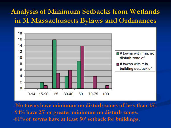
| * NB = Hopkinton allows 10′ utilities, 15′ driveway, Manchester allows 25′ driveway |
| Northborough has lowest no disturb setback of 15′, Methuen has 20′, all others have min. of 25′ |
With 10-foot buffer zones, Northampton is clearly at the narrow end of the spectrum.
Gazette guest column: “Don’t ease controls on wetlands” (10/25/07, emphasis added)
[Alexandra Dawson, chair of Hadley’s Conservation Commission,
writes,] …Northampton has adopted changes to its bylaws that limit
the setback between development and wetlands in the business district
to 10 feet, although it is obvious that 10 feet is not even enough
space to accommodate the big yellow machines that do the building. It
is true that a recent court decision indicates that wetlands ordinances
(or conservation commission regulations adopted under them) should
enumerate setbacks so that builders need not guess what will be
required of them. Unfortunately, there is also case law stating
that whatever is so established limits the commission’s discretion to
ask for more unless there is a specific showing of why one proposal
stands out from the others. If the setback in the ordinance is 10 feet,
it will be very hard for the commission to justify a permit restricting
building for 50 feet. For this reason, most eastern Massachusetts bylaws that contain setbacks start at 25 to 50 feet.
Just Released: Planner’s Guide to Wetland Buffers for Local Governments
Most striking is that some locales desire wider buffers in areas
of intense land use to address the higher levels of pollution and
runoff. By contrast, Northampton has its narrowest buffers in these
areas.
[Flood damage reports from Tropical Storm Floyd
pepper downtown Northampton (1999). Note most of the red flags are
outside the traditional 100-year floodplain. This is a sign that
Northampton’s stormwater management systems are stretched even under
the existing wetlands buffer zone regime. We object to ratcheting up
the pressure on our in-town wetlands, a key part of our natural
drainage system.]
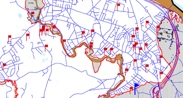
Northampton’s
Flood and Natural Hazard Mitigation Plan: Floyd Flood Damage Reported
Behind View Avenue; Avoid Building on Filled Wetlands
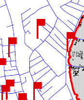
In the map
below, the red flag behind View Avenue (the topmost flag) indicates a
flood damage report from Tropical Storm Floyd (1999). This area is in
the eastern portion of Kohl Construction’s proposed condo site, one of the more elevated portions. We infer that much of Kohl’s property may be at risk from heavy rainfall events.
…In
general, a core problem for infill in Northampton is to avoid placing
large numbers of people and structures in low-lying areas downtown that
may be at risk for flooding. As the plan states, “In recent years,
heavy rainstorms have caused significant problems in more urbanized
areas as increased development inhibits proper drainage and existing or
poorly maintained water systems cannot handle increased stormwater
runoff.”
Northampton Conservation Planner: Wetlands Protection Agreements Are Being Violated
[Responding to a suggestion from Commissioner Kevin Lake to combat the
encroachment problem through covenants:] “We have [an agreement] with
Cardinal Way. We have a covenant that says, there’s a 75-foot
no-disturb area, and there will be granite bollards placed every 25
feet along this 75-foot no-disturb… And what we have is, we have
smashed granite bollards that are sitting in the mowed wetlands. That
people have smashed the bollards, threw them back in the woods, and
then mowed all the way up to edge of the woods…mowed down all the
wetland vegetation and so now what we have is (and there’s a shed
sitting in the middle of the wetland now) and what we have is large
grass and my letters that I sent to them saying, you don’t have the
right to do this, and them coming back to me saying, any letter that
comes to them from the city is refused in the mail…
“My
position has already been cut down to three days for conservation, and
there’s no time for this, and there’s no one else out there doing it…”
“Innovative Non-Zoning Approaches to Encourage Smart Growth and Protect Public Health” – Video with Wayne Feiden and Bruce Young
At 1:13:30 during the Q&A session, Cohen asked Feiden and
Young about the Meadowbrook Apartments. The experience of this
development raises concerns about the hazards of building homes near
wetlands. As former City Councilor Mike Kirby wrote in June:
The developers built 255 units of affordable
apartments there. They crammed them in everywhere they could, pushing
them up into the bluffs, and close to the creek and wetlands. No
backyards to speak of. One third of the buildings were built within 50
feet of the wetlands, 63% of the buildings are within the customary 100
feet of wetlands.None of the buildings have cellars under their
apartments. If they have cellars, there are people living in them. The
cellar floors in the basement apartments in Buildings #4 and #2 are
lower than the surrounding swamp. Some slabs have cracks in them.
People have been flooded out. No moisture-proof barriers between the
surrounding earth and the foundations. Moisture and mold percolate up
into people’s apartments via the chases that hold utilities. If you
wonder why low-income children are afflicted with a whole host of
respiratory diseases, you have to look no further than the children of
the floor level and basement apartments of Meadowbrook…
Feiden and Young were apparently unfamiliar with the problems at
Meadowbrook, and the Q&A session moved on to other subjects.
Before
the city authorizes more housing within 100 feet of wetlands, we urge
the Planning Board or other appropriate body to investigate the
Meadowbrook situation to determine if the proximity to wetlands,
design issues, construction issues, maintenance issues, or other
factors are at fault. Meadowbrook is not the only development in town
with moisture problems. At a 12/11/08 Conservation Commission hearing, Alex Ghiselin, another former City Councilor, told the commissioners:
It’s not clear to me now that we have an effective system [for inspecting and maintaining stormwater systems] or that it’s
funded in any significant way, or that we’ve looked at the legal
problems involved in long-term enforcement and inspection–who will be
responsible over time. I have to tell you as somebody who represented a ward that has a
considerable amount of wetlands, and building in those wetlands, that
that was the knottiest, the most difficult problems that we dealt
with… Once the houses are built there’s really no good solution. I
think of on Winslow, on Nutting, on Elm Street, I think of a continual
problem that has bedeviled people who have owned those houses. The
developers are long gone. These are houses built 25-30 years ago. I
think of my friends John and Sue Norton on Winslow, who spent in excess
of $8,000 last year to move water around their house. Almost everybody
on the northeast side of Winslow has that problem. It’s built along a
series of wetlands and streams… I also think it’s also significant
that the City Councilor with by far the most experience in this city,
Jim Dostal, who worked for the DPW all those years, has personal
experience with buildings built near and in wetlands, and the problems
that they’ve produced for the city over time, was adamantly opposed to
moving to within 10 feet, and is still adamantly opposed, and I hope
that the City Council will revisit this. In the meantime, you should
really move very carefully into this new area.”
Video: Conservation Commission Meeting of 3/12/09; Deadlock on Kohl Condo Proposal; Kohl Seeks to Withdraw Application
3:00:22… Commissioner Paul Wetzel: “…I’m just going to say
something, we’ve spent a lot of time listening… right now as this
plan…I’m inclined to deny it. And its just because…if we were
looking at whether this development has an impact on the wetlands, I
think it’s going to have an impact on the wetlands. And, I see, a
number of things, primarily the underground [detention basin] getting
in the way of the hydrology connections underground…”
3:01:06… Wetzel: “…and the fact that everything is so close,
and the people are…it just seems too crowded, and it seems like for a
first project it’s not a precedent I want to set. Now, having said
that, it’s not to say, I wouldn’t say, there shouldn’t be houses there.
And I see a lot better potential up here because it’s higher ground.
And I also want to say, and I say this with some regret, because I
consider Mr. Kohl to be one of the most creative…and the most
responsive and therefore, I think, the best developer…so it is with
some regret that I say that, because they have done everything that we
asked them to. They’ve moved things back, they’ve tuned things up,
they’ve done all this other stuff… I’m also conscious of the fact
that one of the main points of the [wetlands] ordinance was to get,
however you want to define it…was to get people to develop, and
build, inside urban areas. And to make them much closer to services,
and I think that’s a very admirable goal…
3:11:40… Wetzel: “So to me, getting rid of these guys [points
to condo units 1-10]…is a big help” because they are at a relatively
low elevation close to the water table. He wants more room to be made
for the development’s normal operations, such as snow clearing and snow
storage. He believes that violations of wetlands protection covenants
are likely to occur over time.
3:21:00… Kevin Lake says he would prefer a less dense project
but says this is not enough to induce him to vote against the proposal
based on the mandate of the commission.
3:27:45…
Commissioner Downey Meyer: “So, I got involved with the wetlands
ordinance being asked to come and watch a meeting of the CC. If I’d
known then…but I did watch the process up close and see and
participate in the public input then, and I really feel like my role as
a Conservation Commissioner is to apply the ordinance as written in a
way that reflects what the people of the City of Northampton wanted to
happen to the wetlands, and also the interests that are affected by
wetlands and development around wetlands. We were…given a letter by
attorney Michael Pill [see brief from Pill],
who is a very skilled practitioner in land use law, and it looked at an
issue in the current ordinance that is problematic and as the
discussion about the remediation and removal of the invasives plan
revealed tonight, there is more than one thing in the ordinance that is
problematic.
“And this is the conflict between a provision of
the ordinance 337-10c, ‘Encourage infill development that generally has
a smaller environmental footprint than development in outlying
areas’–I’ll elide some of this–‘the commission hereby waives any of
the 337-10 performance standards that are over and above state law
except as provided in the subsection.’ So, one could read that as
saying, that infill development, I’m sorry, did I say C? …B is the
one that deals with Urban Residential B and Urban Residential C and
waives those. You read further down, and in 337-10e-2 sub B: ‘the
City’s general policy is no encroachment within 50 feet of wetlands.
The commission may allow work within the 50 foot no-encroachment zone
in response to a written request for a waiver, which shall include a
written and plan view assessment as part of the application process as
follows: …projects in certain infill areas in accordance with Table 1
in 337-10 when development includes mitigation measures that will
improve the existing conditions of the wetland or the adjacent upland
areas, and is otherwise permissible under the Massachusetts Wetland
Protection Act.'”
3:30:45…
Meyer: “Attorney Pill’s argument was that in land use law, when there
is ambiguous or conflicting positions, that the court would interpret
the law in a way the favored the landowner’s common use, or, I’m sorry,
common rights of use of the land. So that any restriction would be set
aside. And his interpretation was that in this case, that the
subsection 2, because it is more restrictive, and because it conflicts
with the earlier provision, would have to be set aside.
“I’m
not, I’m not in the position…I didn’t hold the cites, I didn’t make
the cases…I don’t think he writes that memo lightly, and I think he
would get up and vigorously argue it in court. I also know, there is no
legal position on the face of the earth, that you will not find a
lawyer to argue the other side of it, vigorously. And with hope of
success.
“One of my first assignments in law school was to argue
an absolutely miserable side of a moot court case… I felt that I had
been given the short end of the stick, because the other side clearly
had to win, and I had to spend a few weeks trying to figure out a way
to argue this impossible case. The thing that I think is also
important, and I don’t know, because I don’t know the law well enough
in this area, is that in terms of the legislative history of this
provision, Bruce told me that subsection 2 was added after the earlier
section, and was added at the behest of environmental groups who felt
that the ordinance was not protective enough. As written.
“So
that, if the understanding of the people drafting the ordinance was
that the more restrictive provision was added second in time, because
the ordinance as drafted was not adequate, did not provide adequate
protection, that leaves me as a…not as a judge, not as a lawyer…but
as someone who is trying to follow the law as I see it written in front
of me, and…give weight to what the people of the city wanted, that I
think I can’t ignore subsection 2. And in that case, I need to look
between 35 and 50 feet, and I need to say, does this project improve
the conditions of the wetlands or the uplands. And that is why I was so
interested in the possibility of mitigation throughout the entire
wetlands.”
3:33:39… Meyer: “If that’s possible,
then that is a significant benefit to the wetlands…that I weigh. If
it is not possible, then what I have to look at is between 35 and 50
feet, or even up to the 10-foot boundary. I see the planting plan, and
I think the planting plan is a significant benefit. I think that
removing the invasives that are there, and planting species that are
high value for habitat, and…food sources for birds and other wildlife
is very important. But, I also see a lot of the grading…and a lot of
disturbance of existing uplands. That is, there are non-native species,
but they are functioning, as upland habitat, and I guess I also
see…at the north end–and this is where it’s…interesting that Paul
points this out that for him, this is the unproblematic part of the
project, because it’s higher–…unit 21 that falls inside the 50-foot
boundary”
3:34:59… Meyer: “…and I guess on
balance…if I look at the grading, I look at the structure, and the
small parts of the structures that are inside that, I can’t say to
myself that this is improving the upland. And I don’t think I can
argue…that development within 100 feet improves the wetland. If that
was the case then I don’t think we would have a Wetlands Protection
Act, because we could just develop within 100 feet and it would
somehow…improve the wetland.
“I think you are hamstrung in
this situation by the fact that you can’t, under this ordinance, do
anything within the wetland to improve it. And, what you’re left with
is this, 0 to 50 foot zone, which is very hard to do adequate
mitigation to compensate for the significant amount of grading, and the
conversion to…continuous human use for the rest of the future.”
3:36:12…
Meyer: “Now…how would I change the plan to address this? …I think
that for me, more significant than the grading…are the actual units
that are built within the 50-foot boundary. So, you know, unit 21 seems
to me like it’s…going to involve…the most disturbance of soil, and,
and its going to be…it will be the human structure that will be in
the boundary or in the buffer zone for good.
“…I don’t have to
redesign it, but…I think that it’s fair to say that those things,
again, if I’m speaking now because I’m trying to give some indication
of why, I think it’s only fair to say that structures, I think that Mr.
Kohl…made a very concerted effort to get almost all the structures
outside the 50-foot boundary. I think that that’s a statement in his
letter, in his latest letter…one of the things he has tried to do. I
think there was a concerted effort to get the flood control, the
stormwater management structures outside the 35-foot boundary. And so,
as it stands…I can’t say that I see this as meeting the test of
subsection 2.
“And if I could just say about…I think I was
even one of the people who pointed out that this wetland was, had been
degraded. Obviously, it’s been near to a rail line for 100 years–a
narrow gauge rail line. It’s been there for, I think the first train
arrived from Boston in 1884.”
3:38:39…
Meyer: “But at the same time, this is the wetland that the people
living in this part of the city have. It’s their wetland. It might not
look as beautiful as a pristine brook out in Mineral Hills that someone
may have behind their house up there. But it is the wetlands that these
people have…and I don’t think I can say that because it’s ugly now,
because it has been abused, that lets just keep on, let’s keep on
impacting it.
“So, I’ll echo what Paul said, I have been
impressed throughout by the applicant’s willingness to work with the
commission. To take into account…not just the input of the
commission, but the input of the community, which has at times been, I
don’t know if they’ve necessarily taken into account that flexibility
that the applicant has shown, but right now as it, as it is submitted
to me, I don’t think that it meets the test of the ordinance as I
interpret it.”
3:45:39…: Commissioners Kevin Lake and Susan Carbin
signal their inclination to approve the proposal. At 2-2, the
commission is deadlocked. A majority vote is required to approve the
proposal.
3:51:13…: Meyer: “This has been
the problem with this project from the beginning… When the footprint
of the project impinges on the wetlands, there’s no other place to do
improvements… If you had the project heavily concentrated in one end
of the site, going right to 35 feet, but nothing was happening down at
the other end of the site, then there’s some place where you can do
significant mitigation in the 35 to 50 foot zone… I don’t think that
the difficulty is something that is set in stone. I think it’s
generated to a certain extent by the design of the project.”
Comparing the New Hazards Mitigation Plan to the Old One: Wetlands Protection Weakened
“Massachusetts is susceptible to hurricanes and tropical storms.
Between 1851 and 2004, approximately 32 tropical storms; five Category
1 hurricanes, two Category 2 hurricanes and three Category 3 hurricanes
have made landfall. To date, the Commonwealth has not experienced a
Category 4 or 5 hurricane. Aside from direct hits from hurricanes and
tropical storms, the Commonwealth is often affected by their extra
tropical remnants as these storms move up the coast and out into the
Atlantic Ocean. Since the destructive hurricane of 1938, four other
major hurricanes have struck the Massachusetts coast in 1954, 1955,
1960, 1985, and 1991. The last hurricane to make landfall in New
England was Hurricane Floyd, a weak category 2 hurricane, in November
1999. Therefore, it is forecasted that, Massachusetts, and the rest
of New England, is long overdue for a major hurricane to make landfall.
Based on past hurricane and tropical storm landfalls, the frequency of
tropical systems to hit the Massachusetts coastline is an average of
once out of every six years.” (p.28, emphasis added)
As Hurricane Threat Builds, Has Complacency Set In about Flooding?
Infill
sounds great on paper, but when it means paving over green space in
downtown Northampton, it runs contrary to sound flood mitigation
practice. The reality is that much of the remaining green space in
downtown is in low-lying areas that are most susceptible to flooding.
It makes sense to go along with the collective wisdom of the past 350
years and leave them undeveloped.